
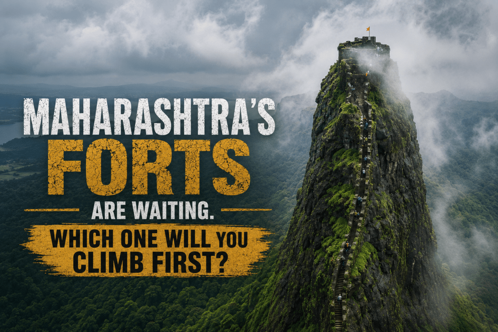
A NOTE FOR 2026 TREKKERS: Maharashtra has more than 160 fort treks across the Sahyadri range. Most were built by Chhatrapati Shivaji Maharaj and his generals as military strongholds watching over the trade routes and passes of the Western Ghats. What stands today — half-ruined, moss-covered, swept with monsoon clouds — is one of the greatest trekking landscapes in Asia. This guide covers the popular, the offbeat, and the ones barely anyone outside nearby villages knows about.
The Morning My Relationship With Forts Changed
My cousin had been calling Rajmachi “just a walk” for three years.
Every monsoon, the conversation was the same: “Yaar, try it once. Two hours from Pune, easy path, you’ll love it.” And every monsoon, I’d find a reason not to — too busy, too far, too many mosquitoes, too much effort for a pile of old rocks.
Then one July, I ran out of excuses.
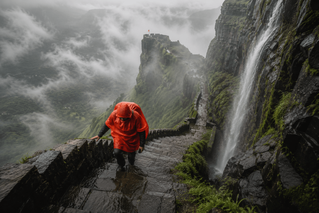
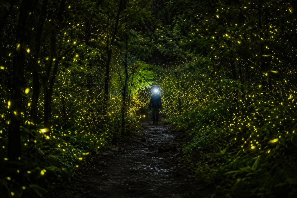
We left Lonavala before 5am, headlamps on, rain already steady. By the time we reached Udhewadi base village, my shoes were wet, my jacket was drenched, and I was questioning every life choice. The first hour was dense forest, mud slipping underfoot, the kind of silence that only exists when rain and leaves and your own breathing are the only sounds.
And then the fort appeared.
Not dramatically. Not all at once. In pieces — first a bastion wall through the trees, then the outline of Shrivardhan in the mist, then the whole thing at once as we crested the ridge and the valley below vanished entirely into white cloud.
I stood there for a long time. Long enough for my companion to get slightly worried.
Maharashtra’s forts don’t announce themselves. They reveal themselves, slowly, to the people who come to find them. That’s the thing about them that no photograph and no description can quite capture — the feeling that you have arrived somewhere. That this was worth getting up at 4am in the rain for. That the 160 forts scattered across these mountains are not ruins of something dead but the heartbeat of something that was, for three hundred years, absolutely alive.
This is the guide that gets you to all of them. The popular ones, the offbeat ones, and the ones where the only directions come from the old man in the village who still knows which path leads up.
Let’s go.
Quick Reference: Maharashtra Fort Trekking 2026
| Category | Details |
|---|---|
| Total forts in Maharashtra | 360+ (160+ trekable) |
| Best season for treks | Monsoon (June–September) for greenery; Winter (October–February) for clear views |
| Coming up: Monsoon 2026 | June 1 – September 30 — the season most trekkers wait for |
| Nearest cities for treks | Mumbai (for Sahyadri west face), Pune (central), Nashik (north Sahyadri) |
| Who built most forts | Chhatrapati Shivaji Maharaj and successors (17th century); some older |
| Emergency helpline Maharashtra | 112 |
| Maharashtra Tourism | maharashtratourism.gov.in |
| MTDC (Maharashtra Tourism Dev Corp) | mtdcholidays.com |
Understanding Maharashtra’s Forts — The History You Need Before You Climb
The Maratha Fort System — Why These Mountains Are Covered in Fortresses
Maharashtra’s forts are not ruins. They are a military philosophy built in stone.
Chhatrapati Shivaji Maharaj understood something that his contemporaries — the Mughals, the Adilshahi sultanate, the Portuguese on the coast — did not: whoever controlled the passes and ridges of the Sahyadri range controlled the trade and movement of the entire Deccan. A fort on a peak that could see for 50 kilometres in every direction was worth more than an army in the plains.
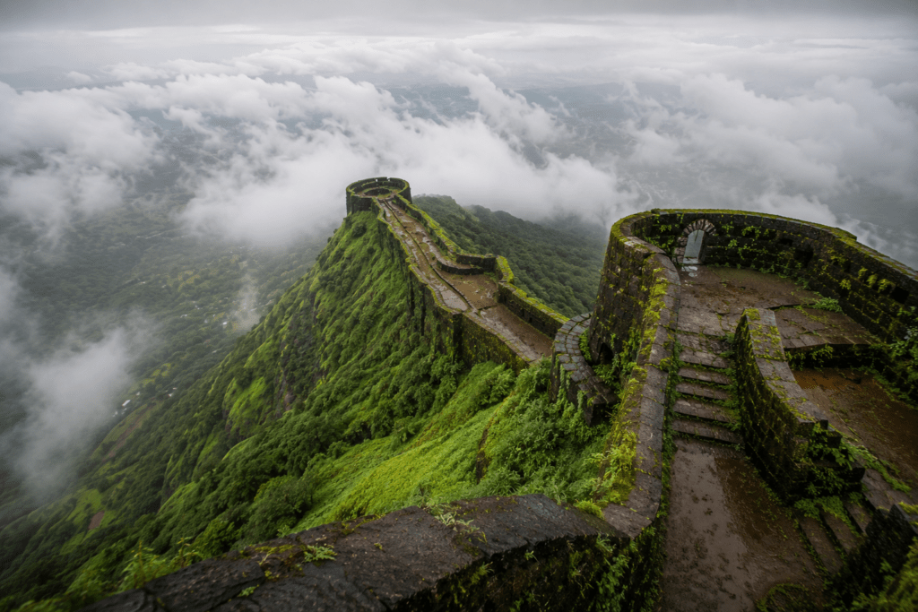
So he built them. Or captured and rebuilt them. One after another, until the Sahyadris — this ancient range of basalt ridges, volcanic rock, and monsoon-carved valleys — became the most heavily fortified landscape in 17th-century Asia.
The forts were not static monuments. They were living systems — with granaries, water cisterns carved into bedrock, temples, residences, cannon positions, and escape routes. The ones that survive (partially, mostly) are the ones that were built with this systems thinking. The plateau of Rajmachi could store water for months. The ramparts of Raigad were positioned to make artillery attack from any direction suicidal. The steps of Harihar Fort were deliberately made so steep that no raiding force could climb them with weapons at any speed.
Walking up these paths in 2026, you are walking the same stone that Maratha soldiers walked in the 17th century. That is not a marketing line. That is a geological fact.
Seasons — When to Go and Why Monsoon Is the Real Answer
Monsoon Season: June — September ⭐⭐⭐⭐⭐ (Peak Fort Trekking Season)
This might surprise you if you’re new to Maharashtra trekking. The rest of India avoids the monsoon. Maharashtra’s fort trekking community waits for it.
Here’s why: the Sahyadri range receives 200–400cm of rainfall during monsoon. In three months, these brown, dry basalt ridges transform into something that no other season can produce. Every cliff face runs with silver waterfalls. The forest on the lower slopes turns an almost aggressive shade of green. The plateaus fill with wildflowers — purple Karvy, white Sonkhamb, yellow Smithia. The clouds move through the valleys below you while you walk above them, which is an experience that no human language has found an adequate word for.
Every trekker who has done Lohagad in October (dry, dusty, crowded) and then done it in August (mist swirling through the arches, waterfalls on the bastion walls, ten minutes of sunshine between two hours of cloud) will tell you without hesitation: monsoon is the correct answer.
What to know about monsoon trekking:
- Trails can be slippery, especially on rock faces and near waterfalls — wear shoes with proper grip
- Some ascents (Harihar’s rock-cut steps, Alang-Madan-Kulang, Sandhan Valley) are genuinely dangerous in heavy rain — local conditions on the day matter
- Start before 7am — weather deteriorates by afternoon in monsoon
- Leeches exist below 1,000m in dense forest — apply salt or tobacco, carry a stick to check vegetation
- The waterfalls are worth every leech
Winter Season: October — February ⭐⭐⭐⭐⭐ (Best Views, Most Comfortable)
Winter is when the Sahyadris reveal their other face. The post-monsoon wash leaves the air extraordinarily clear. From any fort above 1,000m on a winter morning, you can see 80–100 kilometres in every direction — the sea glittering to the west, the Deccan plateau dropping away to the east, the entire arc of the Sahyadri range visible north to south.
October–November: Perfect. Trails are firm but not dusty. Water cisterns at forts are still full. Temperatures are pleasant (18–28°C). This is when Dashain and Diwali crowds move to the famous tourist spots — the trails are comparatively empty, which is extraordinary for a region this popular.
December–January: Colder nights (5–12°C on higher forts), crystal clear days. Night treks and summit camping are best in this window. The Konkan Kada cliff at Harishchandragad in a January dawn is possibly the most dramatic viewpoint in Maharashtra.
February: Light crowds, wildflowers starting to reappear, pleasant temperatures. An underrated month for longer treks.
Summer: March — May ❌ (Avoid for Most Treks)
Heat, dust, dry trails, and empty water cisterns make most fort treks miserable in summer. Night treks (departing at 11pm, summit by 4am) are the summer workaround that experienced local trekkers use. If you must go in summer — trek at night, carry double water, descend before 10am.
Exception: The coastal Konkan forts (Janjira, Vijaydurg, Sindhudurg) are actually pleasant in winter/summer as they’re at sea level — not applicable to Sahyadri treks.
The 25 Forts — Complete Guide
TIER 1: POPULAR FORTS (High Footfall, Well-Marked Trails)
1. LOHAGAD FORT — The Perfect Beginner Fort
Hindi/Marathi name: लोहगड (Lohagad = Iron Fort) Location: Near Lonavala, Pune District Google Maps address: Lohagad Fort, Malavli, Pune, Maharashtra 410406 Altitude: 1,050m (3,444 feet) Base village: Malavli (closest railway station — Malavli on Pune-Mumbai line) Trek distance: 4km one way from Malavli station / 2.5km from parking area Difficulty: Easy Trek duration: 1–2 hours ascent | 1 hour descent Best season: Monsoon (July–September) and winter (October–February)
History: Lohagad is one of the most strategically significant forts in Maratha history. Shivaji Maharaj captured it in 1648 CE, but he was forced to surrender it to the Mughals in 1665 CE by the Treaty of Purandar. Shivaji Maharaj recaptured the fort in 1670 CE and used it for keeping his treasury. The fort was also used by Nana Phadnavis — the brilliant Peshwa administrator — in the late 18th century.
The Vinchu Katta (Scorpion Tail): The main attraction of this fort is the famous Vinchu Katta (Scorpion tail), as it resembles the tail of a scorpion. The tail is roughly 2 km in length and the view from the top is captivating!
Size in layman’s terms: The main fort plateau is roughly the size of 8–10 cricket grounds. The Vinchu Katta extension adds another kilometre.
Pros:
- Most beginner-friendly significant fort in Maharashtra
- Malavli railway station means no private vehicle needed
- Well-marked trail, not dangerous in monsoon
- The Vinchu Katta is genuinely dramatic from the bastion walls
- Visapur Fort visible from top — can do both in one day
Cons:
- Can get very crowded on weekends, especially monsoon weekends
- The most visited fort in Maharashtra — expect company
- Trail becomes a stream in heavy rain — messy but manageable
Who can do it: Ages 6–70 with reasonable fitness. Families with children, first-time trekkers, corporate groups.
Transport:
- By train: Local train Mumbai CST → Malavli (2 hours, ₹50–80). Trek starts directly from station.
- By bus: MSRTC to Lonavala (₹180–250 from Mumbai/Pune), then auto/taxi to Malavli
- By 2-wheeler: Pune to Malavli via NH-48 — 55km. Parking at base available.
- By car: Pune → 55km | Mumbai → 115km. Parking at Malavli village.
Camping: Possible at the fort plateau with tents. No formal camping zones — level ground available near Vinchu Katta base. Carry own tents and water.
Food at base: Tea, poha, vada pav, bhakri-thecha from local stalls at Malavli village. Full Maharashtrian thali at local dhabas. Price: ₹50–150 for a meal.
Itinerary from Mumbai (1 day):
- 5:30am: Mumbai CST local train to Malavli
- 7:30am: Malavli — breakfast at local stall
- 8:00am: Begin trek
- 10:00am: Fort summit — explore Vinchu Katta
- 12:00pm: Descend
- 1:00pm: Lunch at Malavli
- 2:30pm: Local train back to Mumbai
- Total budget: ₹400–700 per person
2. RAJMACHI FORT — Two Forts, One Trek, Fireflies at Night
Marathi name: राजमाची (Rajmachi) Location: Between Lonavala and Karjat, near the Bhor Ghat Google Maps address: Rajmachi Fort, Udhewadi, Raigad, Maharashtra 410201 Altitude: Shrivardhan — 825m | Manaranjan — 765m Base village: Udhewadi (accessible from Lonavala side or Karjat side) Trek distance: 15km from Lonavala side | 10km from Karjat side (via Kondivade) Difficulty: Easy to Moderate Duration: 5–7 hours (full day with both forts) Best season: Monsoon (especially for fireflies, May–June) and October–February
History: The fort was under Shivaji’s reign as it overlooked the trade route of Borghat. There are two fortified structures that are part of this fort: Shrivardhan and Manaranjan, on east and west respectively. These forts were built by the Satavahanas but gained fame under the rule of Shivaji Maharaj, who took over the fort.
The firefly phenomenon: The forest is known to be glowing with fireflies during the premonsoon period. A night trek to Rajmachi fort will let you witness this beautiful scene — hundreds of fireflies glowing in the dark. May–June firefly treks are among the most sought-after experiences in Maharashtra.
Size in layman’s terms: Shrivardhan fort plateau is about the size of 5 cricket grounds. Manaranjan is slightly smaller. The village of Udhewadi sits between them — a living village with actual inhabitants, which is rare in Maharashtra’s trekked forts.
Pros:
- Two forts in one trek — excellent value for effort
- Udhewadi village offers proper meals and basic accommodation
- Accessible from both Lonavala and Karjat — flexibility
- Firefly season is genuinely magical and unlike anything else in Maharashtra
- The Kataldhar waterfall is visible from Shrivardhan in monsoon
Cons:
- 15km from Lonavala side is genuinely long for beginners
- The Lonavala road can be congested on weekends
- The fort ruins are not well-preserved — expect rubble
Who can do it: Ages 10+ with reasonable fitness. The Karjat route is shorter and gentler for families.
Transport:
- By train: Mumbai CST → Karjat (1h 45min, ₹50). Auto/taxi to Kondivade village base (12km, ₹150–250)
- By bus: MSRTC Lonavala → Rajmachi turn (ask driver). Walk/auto 3km to Udhewadi
- By car: Mumbai → 85km via Khopoli | Pune → 70km via Lonavala. Parking at Kondivade or Rajmachi turn.
Camping: Udhewadi village offers basic mattress/floor accommodation at villager homes — ₹300–500/person. Camping with tents on the plateau possible.
Food in Udhewadi: Villagers offer simple Maharashtrian meals — bhakri (jowar flatbread), sabzi, dal, rice. Approx ₹100–150 for a full meal. Chai available throughout.
Itinerary from Pune (1.5 days — overnight):
- Day 1, 4pm: Pune → Lonavala by MSRTC (90 min, ₹120)
- Day 1, 6pm: Trek from Lonavala to Udhewadi (3 hours)
- Night: Stay in Udhewadi village home (₹400)
- Day 2, 5am: Early morning on Shrivardhan for sunrise
- Day 2, 8am: Manaranjan fort
- Day 2, 12pm: Descend
- Day 2, 3pm: Return to Pune
3. HARISHCHANDRAGAD — The Pride of Maharashtra
Marathi name: हरिश्चंद्रगड Location: Ahmednagar District, near Khireshwar village Google Maps address: Harishchandragad Fort, Khireshwar, Ahmednagar, Maharashtra 422601 Altitude: 1,422m (4,665 feet) Base village: Khireshwar (main access), Pachnai, Belpada (other routes) Trek distance: 6km (Pachnai route, easiest) | 9km (Nalichi Vaat, most dramatic) Difficulty: Moderate (Pachnai route) | Difficult (Nalichi Vaat route) Duration: 4–6 hours ascent (Pachnai) | 6–8 hours (Nalichi Vaat) Best season: October–February for the full Konkan Kada cliff view
History: The fort is quite ancient. Its origin is said to have been in the 6th century, during the rule of the Kalachuri dynasty. The various caves probably have been carved out in the 11th century. In these caves are idols of Lord Vishnu. The carvings in the Harishchandreshwar temple and in the cave of Kedareshwar indicate that the fort belongs to the medieval period. Later the fort was under the control of Moghuls. The Marathas captured it in 1747.
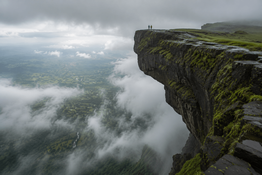
Konkan Kada — The Most Dramatic Cliff in Maharashtra: Harishchandragad’s defining feature is the Konkan Kada — a massive, overhanging basalt cliff that curves outward over a sheer 1,000+ metre drop to the Konkan plains below. A massive, convex cliff with breathtaking views of the Konkan coastline. The cliff is also known for its unique appearance of clouds. Standing at Konkan Kada’s edge — the cliff curves outward beneath your feet — is the most genuinely vertiginous experience available in Maharashtra without technical climbing equipment.
The Kedareshwar Cave: A cave containing a waterlogged Shiva lingam — the water level rises in monsoon and the lingam appears submerged. This cave contains a waterlogged Shiva lingam. The presence of this temple adds to the overall experience of trekking.
Size in layman’s terms: The Harishchandragad plateau is approximately 2km × 1km — roughly the size of 40 cricket grounds. Large enough to lose track of other trekkers easily.
Pros:
- The Konkan Kada cliff is unmissable — nothing else like it in Maharashtra
- Kedareshwar cave and Harishchandreshwar temple are significant heritage sites
- The Saptatirtha Pushkarni (seven sacred ponds) on the plateau is unusual
- Multiple routes to suit different difficulty levels
- Excellent camping on the summit plateau
Cons:
- The Nalichi Vaat route requires basic rock-climbing ability — not for beginners
- Khireshwar is difficult to reach without a private vehicle
- Very popular on October–January weekends — starts feeling crowded by 8am
Who can do it: Pachnai route — ages 12+ with reasonable fitness. Nalichi Vaat — experienced trekkers only, ideally with a guide.
Transport:
- By bus: MSRTC Mumbai/Pune → Khireshwar is indirect. Pune → Sangamner (3 hours, ₹200), then local transport to Khireshwar (not reliable). Private vehicle strongly recommended.
- By car: Mumbai → 191km via NH-61 | Pune → 133km via Sangamner. The last 10km to Khireshwar is kachcha road — 4-wheeler manageable, 2-wheeler possible.
- By 2-wheeler: Possible to Khireshwar but the last stretch is rocky — ride carefully.
Camping: Open camping on the summit plateau — one of the best camping destinations in Maharashtra. Carry own tent and sleeping bag. Water available from cisterns (purify before drinking). Cost: free (no camping permits required in 2026).
Food near base: Khireshwar village has 2–3 local dhabas. Simple Maharashtrian meals — jowar bhakri, dal, sabzi, rice. ₹80–150 per meal. Stock up at Sangamner before reaching Khireshwar.
Itinerary from Pune (2 days — overnight trek):
- Day 1, 2pm: Depart Pune by private vehicle
- Day 1, 6pm: Reach Khireshwar. Dinner and early sleep.
- Day 2, 4:30am: Begin trek by headlamp
- Day 2, 9am: Summit — Konkan Kada, caves, temples
- Day 2, 12pm: Lunch on plateau, rest
- Day 2, 3pm: Begin descent
- Day 2, 6pm: Back at Khireshwar. Drive to Pune (arrive 10pm).
- Budget per person: ₹1,500–2,500 (private vehicle, food, basic accommodation at base)
4. HARIHAR FORT — The Staircase That Defies Gravity
Marathi name: हरिहर किल्ला (Also known as Harshagad) Location: Nashik District, near Nirgudpada village, Igatpuri region Google Maps address: Harihar Fort, Nirgudpada, Igatpuri, Nashik, Maharashtra 422403 Altitude: 1,120m (3,676 feet) Base village: Nirgudpada village Trek distance: 5–7km round trip Difficulty: Moderate to Strenuous (due to near-vertical rock-cut steps) Duration: 3–4 hours ascent | 2–3 hours descent Best season: October–February (rock-cut steps dangerously slippery in heavy monsoon rain)
History: Harihar Fort is a Hemadpanthi-era construction — Hemadpanthi architecture refers to the style of construction prevalent during the Yadava dynasty (12th–13th century CE). The fort was primarily used to watch over the Gomukhi Ghats and trade routes. It was later controlled by the Bahamani Sultanate and subsequently captured by Shivaji Maharaj.
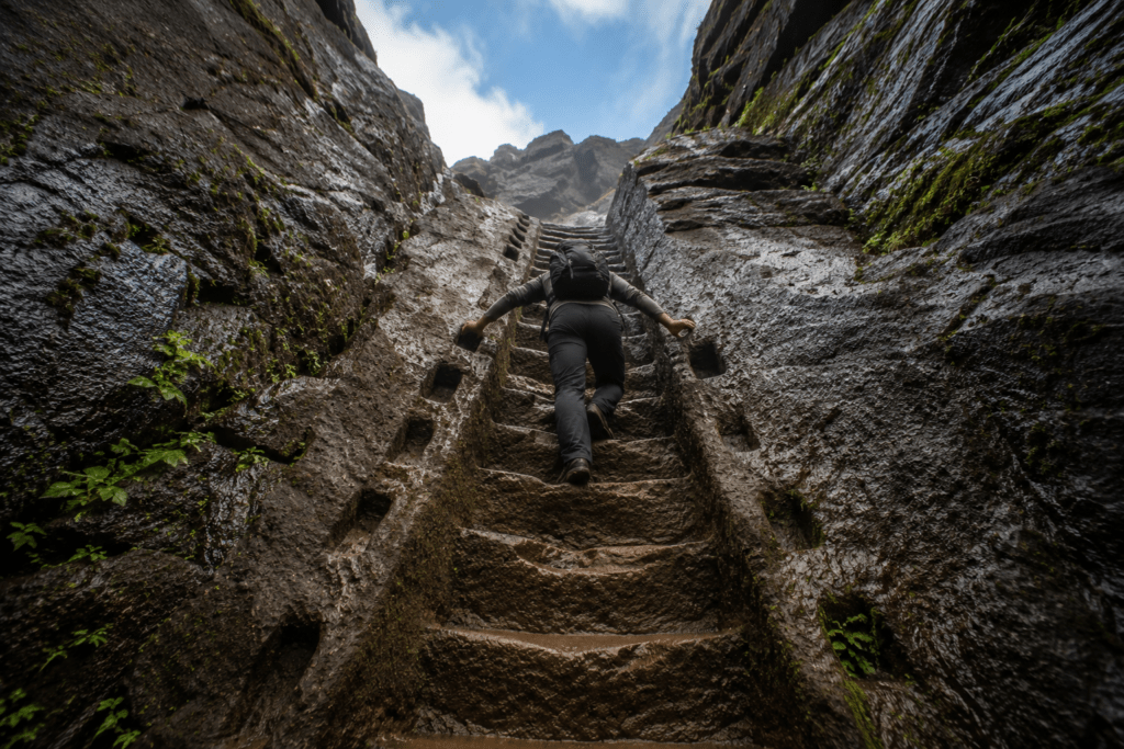
The Rock-Cut Staircase: The Harihar Fort is well known for its steep rock-cut stairways of almost 70 degrees. This trek provides an exhilarating ascent, narrow trails and panoramic views, making it an exciting and unique trekking destination in Maharashtra.
The steps are not metaphorically steep. They are genuinely 70 degrees — you are essentially climbing a wall with handholds. The experience is unlike any other fort in Maharashtra.
Size in layman’s terms: The fort summit is compact — roughly the size of 2 cricket grounds. What makes Harihar special is not the summit area but the journey up.
Pros:
- The 70-degree rock-cut steps are a genuinely unique experience in Maharashtra
- Panoramic views of Sahyadri range from the summit
- Triangular rock pinnacle is one of the most photogenic forts in Maharashtra
- Manageable distance (5–7km round trip) for most fitness levels
- Not as crowded as Lohagad or Rajmachi
Cons:
- Rock-cut steps are genuinely dangerous in wet/monsoon conditions — do this in winter
- Steeper sections require using hands — not for those with vertigo
- Nirgudpada is not on a major road — requires planning
Who can do it: Ages 14+ with good fitness and no fear of heights. Not recommended for young children or elderly on the main staircase sections.
Transport:
- By bus: Mumbai → Igatpuri (Kasara local train, 2.5 hours, ₹60) → MSRTC to Ghoti (₹40) → Local jeep/auto to Nirgudpada
- By car: Mumbai → 130km via NH-160 (through Ghoti) | Nashik → 60km
- By 2-wheeler: Nashik to Nirgudpada is accessible by two-wheeler. Parking at base village.
Food at Nirgudpada: Local homestays offer basic meals. Vada pav, chai, and simple bhakri-thecha available at village. Full meal at villager’s home by arrangement — ₹100–150.
Itinerary from Nashik (1 day):
- 5am: Nashik → Nirgudpada (60km, 1.5 hours)
- 7am: Begin trek
- 10am: Summit — explore, photography
- 12pm: Descend
- 2pm: Lunch at Nirgudpada
- 4pm: Return to Nashik
- Budget: ₹600–1,200 per person including fuel, food
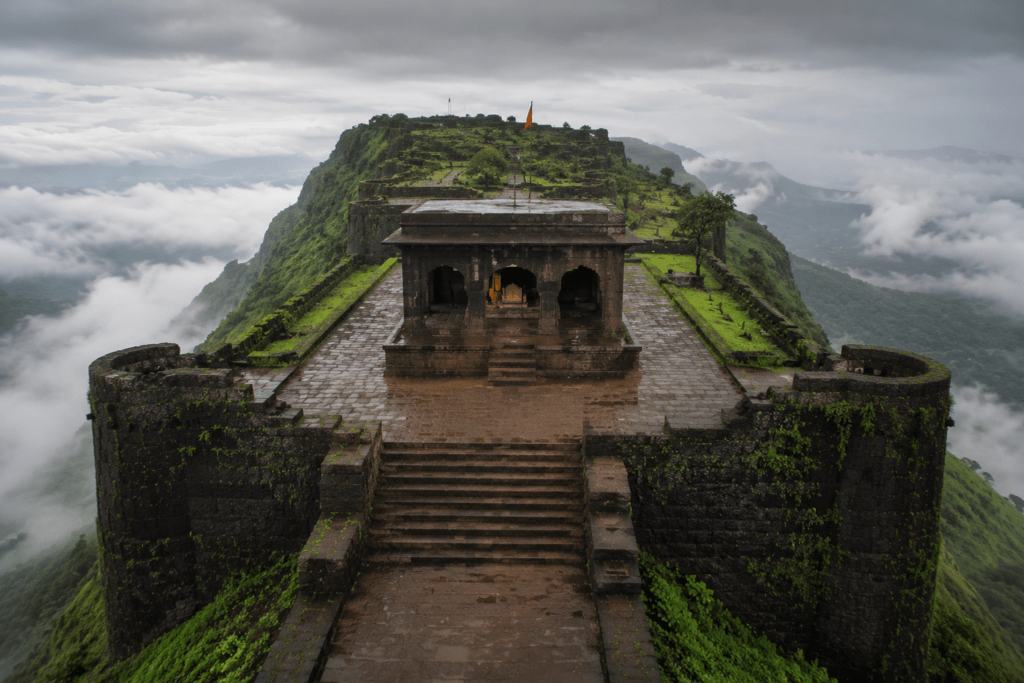
5. RAIGAD FORT — Shivaji’s Capital in the Clouds
Marathi name: रायगड (Raigad = King’s Fort) Location: Raigad District, near Mahad Google Maps address: Raigad Fort, Pachad, Mahad, Raigad, Maharashtra 402301 Altitude: 820m (2,700 feet) Base village: Pachad village (for trek) OR Raigad ropeway station Trek distance: 8km (trek route) | Ropeway: 8 minutes Difficulty: Easy to Moderate (trek) | Easy (ropeway) Duration: 4–5 hours (trek up) | 30 minutes (ropeway) Best season: October–February | UNESCO Heritage Site — open year round
History: Earlier called as Rairi, Raigad was initially under the control of Chandrarao More of Jawali and was captured by Chhatrapati Shivaji Maharaj in 1656 CE. After taking over the Rairi Fort, Shivaji Maharaj got it completely renovated and renamed it as Raigad (the King’s Fort). Shivaji Maharaj made it his capital in 1674 CE when he was crowned as King. The fort was destroyed by the British in 1818 CE after they conquered it.
Raigad is where Shivaji Maharaj was coronated as Chhatrapati (Emperor) on June 6, 1674. The coronation ceremony is recreated as Shiv Rajyabhishek every year. Raigad is also where Shivaji Maharaj died in 1680 — his samadhi (memorial) is on the fort plateau.
Raigad was designated as a UNESCO World Heritage Site as part of the Maratha Military Landscapes in 2024.
Size in layman’s terms: The fort plateau is enormous — approximately 3km × 1.5km, roughly 120 cricket grounds. It had market areas, residential zones, stables, temples, and the royal palace — essentially a functioning hilltop city.
Ropeway: A ropeway from Pachad to the fort is available — adult ₹550 return. Runs daily, closes at 5:30pm.
Pros:
- UNESCO World Heritage Site — historically the most significant fort in Maharashtra
- Ropeway option makes it accessible for seniors and young children
- Well-maintained by Maharashtra Tourism
- Shivaji Maharaj’s samadhi is deeply moving for Maharashtrian visitors
- The Hirkani Buruj (tower named after the legendary milkwoman Hirkani) is a separate attraction
Cons:
- Very touristy — Raigad has become a heavily visited site
- The ropeway means it’s accessible to non-trekkers — the summit can be busy
- Trek route is longer than most Sahyadri forts (8km)
Who can do it: All ages via ropeway. Ages 10+ for the trek.
Transport:
- By bus: Mumbai → Mahad (MSRTC, 4.5 hours, ₹280). Mahad → Pachad (local transport, 25km, ₹80–120)
- By car: Mumbai → 175km via NH-66 and Mahad | Pune → 140km. Parking at Pachad.
- By 2-wheeler: Possible to Pachad — reasonably good road.
Food at fort: MTDC canteen on the fort. Meals available at Pachad village (Maharashtrian thali ₹150–250).
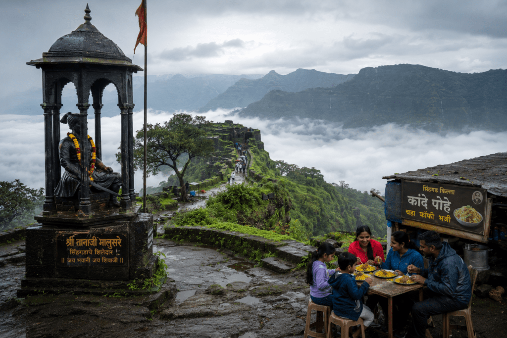
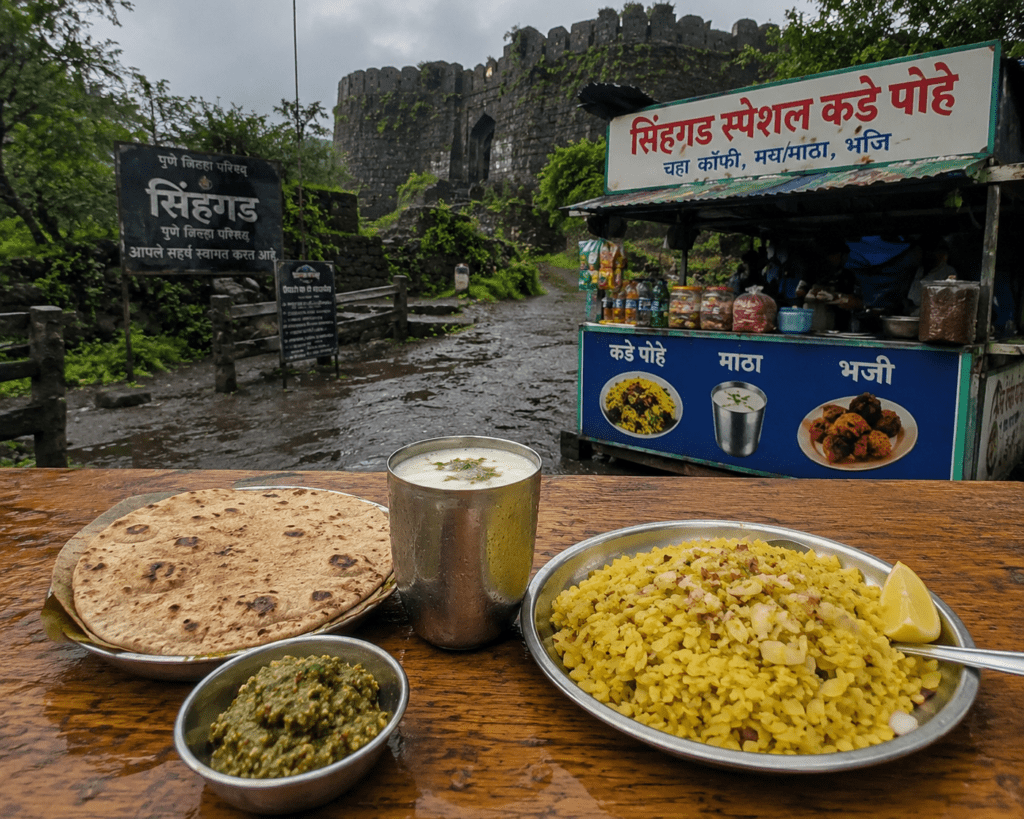
6. SINHAGAD FORT — The Fort of the Lion and the Battle That Changed History
Marathi name: सिंहगड (Sinhagad = Lion’s Fort) Location: Pune District, 25km from Pune Google Maps address: Sinhagad Fort, Sinhagad, Pune, Maharashtra 411025 Altitude: 1,312m (4,304 feet) Base village: Sinhagad village (motorable road exists — most visitors drive) Trek distance: 3.5km from Sinhagad village base | Night trek from Donje Phata Difficulty: Easy (motorable road) | Moderate (proper trek from Donje) Duration: 2–3 hours (proper trek ascent) | Drive available Best season: Monsoon and winter — but accessible year round
History: Sinhagad is where the Battle of Sinhagad was fought on February 4, 1670 — one of the most celebrated battles in Maratha history. Tanaji Malsure, Shivaji Maharaj’s chief general and closest friend, captured the fort from the Mughal garrison with a small group of warriors climbing the cliff at night using a monitor lizard (ghori) to hold a rope. Tanaji was killed in the battle. When Shivaji heard the news, he reportedly said: “Gad ala, paN sinh gela” — “The fort came to us, but the lion is gone.”
Tanaji Malsure’s memorial stands at the spot where he fell.
Size in layman’s terms: The fort covers approximately 420 acres (169 hectares) — about 250 cricket grounds. It’s a large, plateau-type fort with multiple water tanks, bastions, temples, and two gates.
Sinhagad Food Culture: This is the only fort on the list with its own food culture. The stalls near the fort entrance serve:
- Kande Pohe: Fresh flattened rice with onion, mustard, turmeric, coconut — ₹40–70
- Thikhla (Thecha): Green chilli-garlic paste served with bhakri — the iconic Sinhagad accompaniment. ₹30–50 per portion.
- Mattha: Spiced buttermilk — the natural Sinhagad beverage — ₹30–50
Pros:
- 25km from Pune — the most accessible significant fort
- Road goes all the way — great for those who want the history without the trek
- Best food culture of any Maharashtra fort
- Tanaji’s memorial is one of the most emotionally significant Maratha heritage sites
- Excellent for monsoon photography — the clouds consistently sit below the fort level
Cons:
- The road means it’s very crowded — especially Pune residents driving up for poha on weekends
- Not a “proper” trek experience due to road access
Who can do it: All ages. Families with young children, seniors — the road makes this accessible to everyone.
Transport:
- By bus: PMPML Pune → Sinhagad (Bus 50 and others, ₹40–60)
- By 2-wheeler/car: Pune → 25km, excellent road. Parking available at base.
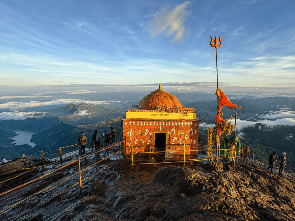
7. KALSUBAI PEAK — The Everest of Maharashtra
Marathi name: कळसूबाई शिखर Location: Ahmednagar District, Bhandardara region Google Maps address: Kalsubai Peak, Bari Village, Ahmednagar, Maharashtra 422604 Altitude: 1,646m (5,400 feet) — Highest peak in Maharashtra Base village: Bari village Trek distance: 8.6km round trip Difficulty: Moderate to Strenuous Duration: 4–5 hours ascent | 3 hours descent Best season: October–February | Monsoon for waterfalls and clouds
History: The peak of Kalsubai perched at an altitude of 5400 feet (1646 m) is the highest peak in Maharashtra. The peak lies within the Kalsubai Harishchandragad Wildlife Sanctuary. It was used for keeping watch on their enemies during the Maratha rule in the region. Kalsubai Temple is located at the topmost peak of the Sahyadri mountain range.
The view from the top: To the north of the mountain range forts such as Ramsej, Harihargad, Brahmagiri, Anjaneri, Ghargad, Bahula, Tringalwadi, Kavnai can be seen. To the east one can spot Aundha, Vishramgad, Bitangad, to the west Alang, Madangad, Kulang, Ratangad (southwest) and to the south Padhargad, Ghanchakkar, Harishchandragad.
The iron ladders: The upper sections of Kalsubai have iron ladders fixed into the rock face — these make the steep sections technically easier but add a vertigo element.
Pros:
- The highest point in Maharashtra — a title with genuine bragging rights
- The view from the top is extraordinary — 360° panorama of the entire Sahyadri
- The Bhandardara dam visible from the summit
- Kalsubai Mata temple at the summit is a spiritual destination
Cons:
- Strenuous — the iron ladder sections require good upper body strength
- Gets very crowded in October–January weekends
- Bari village is not easily accessible without a private vehicle
Who can do it: Ages 14+ with good fitness. The iron ladder sections require confidence with heights.
Transport:
- By bus: Mumbai → Kasara (local train, ₹60) → MSRTC to Ghoti → local vehicle to Bari
- By car: Mumbai → 165km | Nashik → 90km | Pune → 174km. Good road to Bari village.
8. RATANGAD FORT — The Jewel of Sahyadris
Marathi name: रतनगड Location: Ahmednagar District, near Bhandardara Google Maps address: Ratangad Fort, Ratanwadi Village, Ahmednagar, Maharashtra 422604 Altitude: 1,300m (4,265 feet) Base village: Ratanwadi village Trek distance: 6km round trip Difficulty: Easy to Moderate Duration: 3–4 hours ascent | 2–3 hours descent
The Needhe (Eye of the Needle): The Nedhe, or “Eye of the Needle,” is a natural rock crevice that provides stunning valley views. It is one of the most clicked places in Ratangad and offers perfect frames for Sunrise and Sunset Photography. Ancient Caves: Ratangad has traditions of caves where trekkers can have a stopover.
The Needhe is a naturally formed rock arch/crevice in the fort wall — you step through it to find yourself on a narrow ledge above a sheer drop with the entire Sahyadri range visible. The photography is spectacular.
History: This 2000-year-old hill fortress is also known as the Jewels of Sahyadris and is a part of Bhandardara.
Pros:
- The Needhe rock formation is unique in Maharashtra
- Easy to combine with Bhandardara dam visit and Kalsubai
- Beautiful waterfalls in the descent section during monsoon
- Ratanwadi village is charming — homestay culture active here
Cons:
- Remote — requires private vehicle or advance planning
- The cave section can be dark — carry a torch
Transport:
- By car: Mumbai → 165km | Nashik → 90km
- By bus: Mumbai → Ghoti (Kasara train then bus, 3.5 hours), Ghoti → Ratanwadi (local transport, 25km)
TIER 2: OFFBEAT FORTS (Moderate Footfall, Some Route-Finding Required)
9. RAJGAD FORT — Shivaji’s True First Capital
Marathi name: राजगड (Rajgad = King’s Fort) Location: Pune District, near Bhor Google Maps address: Rajgad Fort, Waje Village, Bhor, Pune, Maharashtra 412206 Altitude: 1,376m (4,514 feet) Base village: Pali (main access), Gunjavane (alternate) Trek distance: 10km one way (Pali route) Difficulty: Moderate to Challenging Duration: 5–7 hours ascent
History: Rajgad was Shivaji Maharaj’s capital for 26 years (1648–1674) before he shifted to Raigad. It was here that most of the early Maratha Empire was administered. The fort is massive — three separate machi (plateaus) at different levels with distinct defensive purposes.
Size in layman’s terms: Rajgad is one of the largest forts in Maharashtra — the three machis together cover approximately 1,500 acres (600 hectares) — roughly 900 cricket grounds. You need a full day to explore it properly.
Pros:
- The most historically significant fort in Maharashtra alongside Raigad
- Three separate machis provide varied terrain and exploration
- Balekilla (inner citadel) is one of the finest examples of Maratha military architecture
- Less crowded than Sinhagad despite similar Pune proximity
Cons:
- Long trek — 10km one way is serious
- Pali route requires navigating with a guide on some sections
- The descent can be knee-heavy after a full day at the top
Camping: Excellent camping on the Padmavati Machi plateau. Water available from cisterns. One of the best overnight fort camping experiences in Maharashtra.
Transport:
- By bus: Pune → Bhor (MSRTC, 1.5 hours, ₹80) → Pali (local auto/taxi, 15km)
- By car: Pune → 60km via Bhor-Velhe road
10. TORNA FORT (PRACHANDAGAD) — The First Fort Shivaji Captured
Marathi name: तोरणा / प्रचंडगड Location: Pune District, near Velhe Google Maps address: Torna Fort, Velhe, Pune, Maharashtra 412212 Altitude: 1,403m (4,603 feet) — One of the highest forts in Maharashtra Base village: Velhe Trek distance: 8km one way Difficulty: Moderate to Challenging Duration: 5–6 hours ascent
History: Torna Fort was the first fort captured by Shivaji Maharaj in 1646, at just 16 years of age. This capture is considered the founding moment of the Maratha Empire. Shivaji found a treasure in the fort granary and used it to begin construction of Rajgad nearby.
The name: When Shivaji captured the fort, the enormous size of the fortification led him to rename it Prachandagad (Prachand = enormous, mighty). The name Torna came from Toranai Devi, the goddess worshipped at the fort.
Pros:
- Historical significance as the founding moment of the Maratha Empire
- One of the highest forts — extraordinary views
- Less crowded than Rajgad or Sinhagad despite similar location
- Mengai Devi temple at the summit
Cons:
- Long, steep trek — not for beginners
- Limited facilities at Velhe base
- Combined with Rajgad, requires 2 days minimum
Transport:
- By car: Pune → 70km via Nasrapur-Velhe road (excellent scenic drive)
- By 2-wheeler: Possible to Velhe
11. SUDHAGAD FORT — The Sweet Hidden Fort Near Pali
Marathi name: सुधागड / भोरपगड Location: Raigad District, near Pali Google Maps address: Sudhagad Fort, Pali, Raigad, Maharashtra 402304 Altitude: 624m (2,047 feet) Base village: Thakurwadi / Dhangawadi Trek distance: 5km one way Difficulty: Easy to Moderate Duration: 2–3 hours ascent
Special feature: Sudhagad trek is a short and sweet weekend getaway for trekkers from Mumbai and Pune. The fort is almost equidistant from both the cities. One can see the peaks of Sarasgad, Tail Baila and Ghangad from the top. There are 2 huge lakes at the top where one can take a dip and build a camp for a night’s stay.
The two lakes at the top are the unique feature — natural rainwater cisterns large enough to swim in during monsoon. The Bhorai Devi temple on the fort gives the alternate name Bhorapgad.
Transport: Pune/Mumbai → Pali → Thakurwadi (private vehicle most practical)
TIER 3: OFFBEAT AND LOCALLY KNOWN FORTS
12. TRINGALWADI FORT — The One Near Igatpuri Nobody Talks About
Marathi name: त्रिंगलवाडी Location: Nashik District, near Igatpuri Google Maps address: Tringalwadi Fort, Tringalwadi, Igatpuri, Nashik, Maharashtra 422403 Altitude: 900m approximately Base village: Tringalwadi village
Why it’s special: Tringalwadi Fort, perched atop a scenic hill, offering panoramic views of the surrounding valleys and lush greenery. The fort sits above the Tringalwadi Lake, which reflects the fort dramatically in calm conditions. Almost entirely unknown outside Nashik trekkers.
Who knows about this: Local guides from Igatpuri and Ghoti. The fort has no formal trail — follow the path from the villagers at Tringalwadi village base.
Transport: Nashik → Igatpuri (30km) → Tringalwadi village (15km, local roads). 2-wheeler recommended for the last section.
13. KAVNAI FORT — The Spiritual Hidden Climb
Marathi name: कावनाई किल्ला Location: Nashik District, near Igatpuri Google Maps address: Kavnai Fort, Kavnai Village, Igatpuri, Nashik, Maharashtra
Why it’s special: Kavnai Fort is a relatively lesser-known trekking destination. The trek to Kavnai Fort takes you through scenic landscapes, dense forests, and serene meadows. Kavnai Fort is particularly enchanting during the monsoon season when the entire region comes alive with lush greenery and gushing waterfalls.
Kavnai Fort stands as one of the least explored mountains climbs in the Sahyadri ranges. You can also visit the spiritual place Kapilatirth that is located near the Kavnai village. Soak in the panoramic view of Kalsubai, Trimbakeshwar, and Tringalwadi forts from the top.
Local food: Relish delicious homemade meals consisting of traditional Maharashtrian delicacies at the village homestays — genuinely home-cooked food from Kavnai village families.
14. DHODAP FORT — The Second Highest and Underrated
Marathi name: धोडप किल्ला Location: Nashik District Base village: Dhodap village, near Chandwad Altitude: 1,489m (second highest fort in Maharashtra) Difficulty: Strenuous
Why it’s special: Unknown to many, the fort offers great trekking experiences one can ask for. Packed with many surprises, the Dhodap Fort Trek has a variety that stands out to make it one of the best treks to do in Maharashtra.
The second-highest fort in Maharashtra receives a fraction of the attention of Kalsubai — for serious trekkers, this is the advantage.
15. ANJANERI FORT — Where Hanuman Was Born
Marathi name: अंजनेरी Location: Nashik District, near Trimbakeshwar Google Maps address: Anjaneri Fort, Anjaneri, Trimbakeshwar, Nashik, Maharashtra 422212 Altitude: 1,300m (4,264 feet) Difficulty: Moderate Best season: December
Why it’s special: The Mountain derived its name from Anjani Mata, the mother of Lord Hanuman. Lord Hanuman spent his entire childhood on the Mountain. Anjaneri fort trail is thrilling, which goes through dense bushes, caves, lakes, and waterfalls. The pinnacles of ‘Navara’ and ‘Navari’ can be seen from Anjaneri village.
The spiritual significance — this is traditionally considered the birthplace of Hanuman — makes Anjaneri unusual. Local villagers from Trimbakeshwar and Nashik trek here for religious purposes as well as adventure.
16. ROHIDA FORT — Where the Wind Goes Upward
Marathi name: रोहिडा किल्ला (Vichitragad) Location: Pune District, near Wai
Why it’s special: If you have never experienced raging winds, Rohida, a fort near Pune, is a must-do trek. If you are trekking in monsoon, on the left side of the ridge you see waterfalls that flow upwards, so fierce is the wind here.
The inverted waterfalls — water blown upward by the ridge winds — are one of the most unusual natural phenomena available on any Maharashtra fort trek.
17. PRABALGAD FORT — The Hidden Giant Near Mumbai
Marathi name: प्रबळगड Location: Raigad District, near Panvel/Matheran Google Maps address: Prabalgad Fort, near Panvel, Raigad, Maharashtra
Why it’s special: Prabalgad Fort, near Mumbai, promises thrilling trails and panoramic vistas. As you ascend, you’ll witness panoramic views of the picturesque surroundings, including the towering peaks of Matheran and Chanderi.
Only 75km from Mumbai but rarely crowded because the trail requires route-finding through dense forest. Most people who know about Prabalgad learned about it from a local Karjat trekker. The approach from Thakurwadi village involves traversing the Prabalmachi plateau — one of the finest high plateaus near Mumbai.
18. ASHERIGAD FORT — Palghar’s Hidden Treasure
Location: Palghar District Why special: Located in the Palghar district, Asherigad Fort is a hidden gem known for its steep slopes and captivating ruins. The trek to Asherigad is thrilling, taking you through dense forests, rocky patches, and awe-inspiring landscapes.
One of the few significant forts in the Palghar district — almost entirely unknown to Mumbai trekkers despite being relatively close. The ruins are dramatic.
Forts Almost Nobody Has Trekked — For the True Adventurers
The Untrekked and Near-Untrekked
Maharashtra’s 360+ forts have a long tail of almost completely unknown, untrailed destinations that only village elders and a handful of experienced historians know how to access. Here are the genuinely wild options:
Bhairavgad (Moroshi): Location: Near Bhimashankar, Pune District. Different from the better-known Bhairavgad in Nashik. Accessible only through dense Bhimashankar Wildlife Sanctuary forest. No formal trail. The local Mahadev Koli tribal communities near Moroshi village know the route. Requires 2 days and a local guide hired from Moroshi village. Almost no documented trek records online.
Sindola Fort: Sindola fort trek is one of the lesser-known treks in Malshej ghat in Junnar region. The ruins of bastions, a few water reservoirs and a Ganesha idol at the entrance, at the top of the fort will set you wondering of the beauty. The rock-cut steps while climbing to the pinnacle will leave you astonished. The Ridge walk on the Sindola Fort trek is a celebration for the eyes. Only Junnar-area trekkers and local guides know this route.
Chanderi Fort: Chanderi is a majestic massif and a historical monument. There are no fortifications at the site, but only water cisterns, rock cut steps and caves that denote that the historical site is indeed a fort. Chanderi Fort was captured by Shivaji Maharaj from the Mughal Sultanate. The fort offers the best of both worlds and appeals to both history lovers as well as adventure enthusiasts.
Alang-Madan-Kulang (AMK): The Holy Trinity of Difficult Maharashtra Trekking Valley surrounded with mighty Alang, Madan and Kulang — Known as AMK — the toughest trek in Sahyadri. Alang Madan Kulang is undoubtedly one of the most demanding and considered to be one of the toughest treks in Maharashtra. If you haven’t done it you haven’t finished trekking in Maharashtra. This trek is the test of your mental and physical stamina, confidence, and endurance.
AMK requires: technical rock climbing skills, rope handling experience, minimum 2 days, an experienced guide, and a genuine assessment of your physical condition. This is not a weekend fort trek — this is an expedition.
What to Eat at Maharashtra Fort Treks
The Fort Trek Food Culture
The food culture around Maharashtra’s forts is one of the great underrated pleasures of trekking here. These are not just “fuel for the trail” — the local food at the base villages is genuinely excellent Maharashtrian cooking that has barely changed in generations.
Jowar Bhakri (जोवार भाकरी): The staple. A thick, unleavened flatbread made from jowar (sorghum) flour — slightly smoky from the wood fire, with a nutty, earthy flavour. Served with:
- Thecha/Thikhla (ठेचा): Green chilli and garlic pounded together into a coarse paste — sharp, pungent, addictive. The essential Sinhagad accompaniment.
- Pithla (पिठलं): A gram flour (besan) preparation cooked with onion, garlic, and green chilli into a thick, savoury gravy. The trekker’s preferred vegetarian side dish. Price: ₹50–100 for full bhakri-thecha-pithla meal at base village
Kande Pohe (कांदे पोहे): The pre-trek breakfast across Maharashtra. Flattened rice (poha) cooked with onion (kanda), mustard seeds, curry leaves, turmeric, fresh coconut, and coriander. Light, quickly digested, perfect carb loading before a climb. Best at: Sinhagad base stalls, base village dhabas across Maharashtra Price: ₹40–70
Mattha (ताक / मठ्ठा): Spiced buttermilk — curd blended with water, tempered with cumin, salt, and fresh coriander. The natural hydration and probiotics make it the perfect post-trek drink. On a hot day after a descent, nothing else comes close. Price: ₹30–60 at base villages
Varan Bhaat (वरण भात): The simplest, most nourishing lunch — toor dal cooked without heavy spicing, served with rice and a generous pour of ghee. The simplest version of Maharashtrian home cooking. Found at any local dhaba at fort bases. Price: ₹80–150 for full meal
Chakli (चकली) and Chivda: Fried rice flour spirals (chakli) and spiced flattened rice mix (chivda) — the Maharashtra trekkers’ trail snack. Available at every base village. Buy before ascending. Price: ₹50–100 per packet
Misal Pav (at Pune-region forts): The most celebrated Pune breakfast — sprouted moth bean curry in a fiery red gravy topped with farsan, raw onion, lime, and served with pav. Available at Pune-proximate forts (Sinhagad, Rajgad, Torna base). Price: ₹100–150
What to Carry — Season-wise Gear Guide
Monsoon Trekking Kit (June–September)
The monsoon season requires specific preparation that most first-timers underestimate.
Footwear:
- Waterproof hiking shoes with aggressive lug soles (Decathlon Quechua MH520 or similar, ₹2,000–4,000) — OR
- Old sports shoes you don’t mind getting destroyed
- NOT: Sandals, flip-flops, or smooth-soled trekking sandals on wet rock
Clothing:
- Quick-dry synthetic or polyester T-shirt — cotton holds water and causes chafing
- Light trekking pants or quick-dry shorts — never jeans
- Compact waterproof rain jacket or poncho (₹800–2,500 for a decent one)
- Change of dry clothes sealed in a waterproof bag or ziplock in your bag
Bag:
- 20–30L daypack with rain cover
- Dry bag or large ziplock for phone, wallet, and important items inside
Essentials:
- 2 litres of water minimum (more for longer treks)
- ORS/electrolyte sachets (₹5–10 each, take 4–6) — dehydration happens even in rain
- Trail snacks: Chakli, energy bars, nuts, dry fruits
- First aid kit: Band-aids, antiseptic cream, bandage, paracetamol
- Headlamp with fresh batteries (for early morning starts)
- Trekking pole (optional but helpful on slippery descents)
Monsoon specific:
- Leech socks (₹200–400) or tuck pants into thick socks — for lower elevation forest trails
- Salt sachets for leeches (don’t panic — they are harmless)
- Plastic bag to protect camera/phone
- Extra pair of socks (dry pair in ziplock)
Winter Trekking Kit (October–February)
Footwear: Same as monsoon — good grip on morning frost-damp rock Clothing additions:
- Fleece or light down jacket for early morning starts (temperature 8–15°C on summits)
- Beanie/woollen cap for night treks and dawn summits
- Full-fingered gloves for high-altitude forts above 1,200m (Kalsubai, AMK, Harishchandragad)
Additional winter kit:
- Sleeping bag (if camping — rated to 5°C minimum for Maharashtra winter camping)
- Insulation mat for camping
Fitness and Safety by Trek Level
Fitness Requirements by Level
Beginner (Ages 6–65, Minimal Fitness Required): Forts: Lohagad, Rajmachi (Karjat route), Visapur, Sinhagad (trek), Ratangad
- Basic requirement: able to walk 4–6km at a gentle incline without stopping
- No prior trekking experience needed
- Wear: Comfortable sports shoes, t-shirt, shorts or trekking pants
Moderate (Ages 10–55, Average Fitness): Forts: Rajmachi (Lonavala route), Rajgad, Sudhagad, Anjaneri, Harishchandragad (Pachnai)
- Requirement: Regular walking/exercise, comfortable with 8–12km
- Recommended: 2–3 walking sessions per week in the month before
Advanced (Ages 14–45, Good Fitness): Forts: Harihar, Torna, Harishchandragad (Nalichi Vaat), Kalsubai, Dhodap
- Requirement: Regular trekking or running experience, comfortable with steep inclines
- Some sections require using hands on rock faces
Expert Only (Ages 18–40, Trained Trekkers): Treks: Alang-Madan-Kulang (AMK), Sandhan Valley, Dhak Bahiri
- Requirement: Technical rock climbing skills, rappelling experience, professional guide mandatory
Medical Precautions for Fort Trekking
Monsoon specific:
- Leptospirosis risk from water bodies and muddy areas — avoid wading in stagnant water, cover cuts and scrapes
- Dehydration is paradoxically common in monsoon (you don’t feel thirsty in the cool) — drink on a schedule, not just when thirsty
- Slippery rock causes most fort trek injuries — slow down on descents, especially in wet conditions
Altitude precautions: Maharashtra forts are not high enough to cause AMS (Acute Mountain Sickness), but rapid exertion at 1,200–1,600m can cause breathlessness in unacclimatised visitors. Stop and breathe — it passes quickly at these altitudes.
Emergency contacts at major fort areas:
- Pune District emergency: 100 | 112
- Nashik District: 100 | 112
- Raigad District: 100 | 112
- Mountain Rescue Team Pune: +91-20-25530074
- SDRF Maharashtra: 020-26127394
Tour Packages with Inclusions and Exclusions
Popular Trek Organizers in Maharashtra (2026)
Indiahikes (indiahikes.com) Best for: Organized, safety-focused group treks with licensed guides Routes: Kalsubai, Harishchandragad, Ratangad, Sandhan Valley Typical inclusions: Certified trek leader, first aid, transportation from pickup point, meals on trek, tent accommodation on overnight treks, trekking permit fee Typical exclusions: Personal travel insurance, personal gear (shoes, rain jacket, etc.), meals at base village outside trek days, personal snacks Approximate cost: ₹1,500–3,500 per person per day (varies by trek)
Treks and Trails India (treksandtrails.org) Best for: Mumbai-based trekkers, monsoon treks, offbeat Sahyadri exploration Routes: All major Sahyadri forts, firefly treks, monsoon specialities Typical inclusions: Trek leader, first aid, base camp accommodation (specified), most meals, transport from Mumbai for group departures Approximate cost: ₹1,200–2,800 per person
The Great Next (thegreatnext.com) Best for: Adventure combo packages (trek + rafting, trek + camping) Routes: Rajmachi, Harishchandragad, Kalsubai combinations Approximate cost: ₹1,500–3,000 per person
Trekmunk (trekmunk.com) Best for: Sahyadri treks with consistent weekend departures Approximate cost: ₹1,200–2,500 per person
DIY Budget Estimate Per Fort Trek (Per Person)
| Trek | Transport (from Pune) | Food | Guide | Total |
|---|---|---|---|---|
| Lohagad | ₹200 (train) | ₹300 | Optional | ₹500–700 |
| Rajmachi | ₹350 (train+auto) | ₹400 | Optional | ₹750–1,200 |
| Harishchandragad | ₹800 (car split) | ₹500 | ₹800 | ₹2,100–3,000 |
| Harihar | ₹600 (car split) | ₹400 | ₹500 | ₹1,500–2,200 |
| Raigad | ₹700 (bus+transport) | ₹500 | Optional | ₹1,200–2,000 |
| Kalsubai | ₹800 (car split) | ₹500 | ₹600 | ₹1,900–2,800 |
Itineraries from Major Cities
From Mumbai — Weekend Warriors
Saturday Morning Fort (Lohagad/Visapur):
- 5:30am: Mumbai CST local to Malavli (₹60)
- 7:30am: Begin trek
- 12pm: Summit + descent
- 2pm: Return train Mumbai
- Total: ₹500–900 per person, done by 5pm
Rajmachi Overnight (Perfect Mumbai Weekend):
- Friday 9pm: Night bus Dadar → Lonavala (₹250)
- Saturday 4am: Lonavala → trek start via taxi (₹300 split)
- Saturday 8am: Udhewadi, breakfast with villagers
- Saturday 9am: Shrivardhan fort
- Saturday 1pm: Manaranjan fort
- Saturday evening: Night stay at Udhewadi (₹400)
- Sunday 5am: Sunrise on Shrivardhan
- Sunday 11am: Descent and return
From Pune — Day Trip Capital
Pune is the best-positioned city for Maharashtra fort trekking — 8 major forts within 80km.
The Pune Fort Week:
- Monday: Sinhagad (25km) — sunset and pohe
- Weekend 1: Rajgad + Torna (2-day combo, 60km)
- Weekend 2: Harishchandragad (133km, overnight)
- Weekend 3: Sudhagad (90km, day trip)
- Weekend 4: Purandar Fort (35km from Pune, easy day trip)
From Nashik — The Northern Sahyadri Circuit
Nashik sits at the centre of the northern Sahyadri region — home to Harihar, Kalsubai, Ratangad, Anjaneri, and Kavnai within a 90km radius.
Nashik Fort Weekend Circuit:
- Saturday: Harihar Fort (60km from Nashik) — early start, back by evening
- Sunday: Anjaneri Fort (30km from Nashik) — half day, spiritual + scenic
FAQ Section
Q: What is the best time to trek Maharashtra forts?
A: Monsoon (June–September) is the most visually dramatic — waterfalls, green landscapes, cloud-filled valleys. Winter (October–February) is the most comfortable with clear skies and best views. Avoid summer (March–May) for most forts except for night treks.
Q: Are Maharashtra fort treks safe during monsoon?
A: Most popular fort treks (Lohagad, Rajmachi, Sinhagad, Ratangad) are safe during monsoon with proper footwear and reasonable precautions. Technical treks (Harihar’s rock-cut steps, AMK, Sandhan Valley) should be avoided in heavy rain. Always check local weather and trail conditions on the day of trekking.
Q: Do I need a guide for Maharashtra fort treks?
A: For popular marked trails (Lohagad, Sinhagad, Raigad, Rajmachi), guides are not mandatory but recommended for beginners. For offbeat forts (Harishchandragad’s Nalichi Vaat route, AMK, Chanderi, Kavnai, Tringalwadi), a local guide is strongly recommended — trails are unmarked and route-finding is difficult.
Q: What is the cheapest fort trek from Mumbai?
A: Lohagad is the cheapest — the entire day trip costs ₹400–700 per person using the local train to Malavli station. No guide needed, no vehicle needed, trail well-marked.
Q: Can senior citizens and children do Maharashtra fort treks?
A: Yes — specifically Raigad (ropeway option), Sinhagad (road access), and Lohagad (easy trek) are suitable for seniors and children above 6 years. Most other forts have moderate to challenging terrain not suitable for very young children or elderly without regular exercise.
Q: Is camping allowed at Maharashtra forts? A: Camping is generally permitted at most Maharashtra fort plateaus without formal permits in 2026. Popular camping forts include Harishchandragad, Rajgad, Sudhagad, and Torna. Carry your own tent, sleeping bag, and food. No facilities — pack out all waste.
Q: What food should I carry for a one-day Maharashtra fort trek?
A: 2 litres of water, ORS/electrolyte sachets, chakli or energy bars, dry fruits, nuts, and glucose biscuits for the trail. Eat a full breakfast before starting and plan a hot meal at the base village on return. Avoid heavy food before ascending.
Conclusion — The Forts Are Not Going Anywhere. But Go Anyway.
The Sahyadri range has been standing for approximately 65 million years. The forts have been standing for 300–500 years. Neither is in any particular hurry.
But here’s what I’ve noticed: the monsoon of 2026 will be the most dramatic one in your memory from this moment forward, regardless of how many previous monsoons you’ve experienced. The winter of 2026–27 will have the clearest Sahyadri skies of any year you can remember. The particular morning you choose to climb Harihar’s steps will be the morning the clouds sit just right in the valley below.
None of this is guaranteed. All of it is possible.
The people who trek to these forts — from the 19-year-old engineering students from Pune who do Rajmachi in the firefly season to the 55-year-old history professor who finally gets to Raigad and stands at Shivaji Maharaj’s coronation platform with tears on his face — they all say the same thing: I should have done this sooner.
Pack your bag. Set the 4am alarm. Eat the bhakri-thecha at the base village.
Go find the fort that was waiting for you.
Jai Shivaji.