

BEFORE YOU START READING: This guide covers 20+ of India’s most scenic road routes — from the Manali-Leh Highway in the Himalayas to the coastal NH-66 between Mumbai and Goa, from the desert roads of Rajasthan to the misty coffee plantations of Coorg. Each route includes distances, best seasons, food stops, driver/rider difficulty ratings, nearby places, and specific itineraries. Grab a chai. This is going to take a while.
The Road That Never Really Ends
The first long road trip I ever did in India started as a mistake.
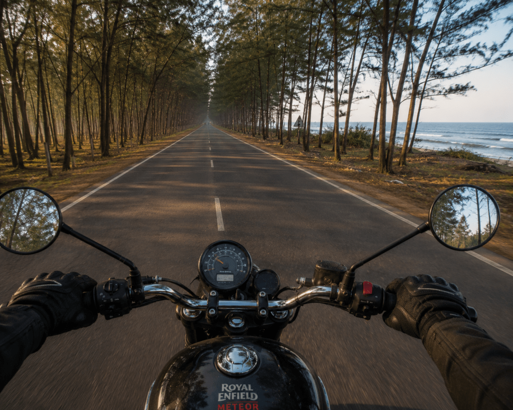
I was supposed to take the train from Delhi to Manali. The waiting list didn’t clear. My friend had a bike, a Royal Enfield Thunderbird that smelled like oil and optimism, and a completely unjustified confidence in both our abilities to ride 560 kilometres through mountains we’d never seen before.
We left Delhi at 4am. By noon we were past Chandigarh and the plains were already behind us. By evening we were climbing the Beas valley and the air had changed — cooler, thinner, carrying the specific smell of pine and glacial water that you never forget once you’ve encountered it. By night we were in Manali, legs aching, fingers slightly numb, wide-eyed in the way that only a genuinely unexpected experience produces.
That trip was fifteen years ago. I’ve done thirty road trips in India since. By bike, by car, by borrowed vehicle, by rental. I’ve done the Ladakh circuit and the coastal NH-66 and the East Coast Road and the Rann of Kutch desert route and the Konkan cliffs and the Coorg coffee plantation roads and the Cherrapunjee fog road.
Every single one of them delivered something the equivalent flight or train never could: the journey itself as the destination. The tea stall 40km from anywhere serving the best chai of your life. The roadside dhaba where the dal makhani has been simmering since before you were born. The viewpoint that’s not on any map where you stop the vehicle and stand for twenty minutes because the valley below is too large to process quickly.
This guide covers twenty of India’s greatest road trip routes. Both bike and car perspectives. Real distances, real food stops, real difficulty ratings, real seasonal advice.
The roads are all there. They’ve been there for years. The only question is when you’re finally going to drive them.
Let’s plan.
Quick Reference: India’s Great Road Routes 2026
| Route | Distance | Best Season | 2-Wheeler | 4-Wheeler | Highlight |
|---|---|---|---|---|---|
| Manali → Leh | 475km | June–September | ⭐⭐⭐⭐⭐ | ⭐⭐⭐⭐ | World’s highest motorable roads |
| Delhi → Leh | 1,000km | June–September | ⭐⭐⭐⭐⭐ | ⭐⭐⭐⭐⭐ | Crown jewel of Indian road trips |
| Mumbai → Goa (NH-66) | 600km | Oct–March | ⭐⭐⭐⭐⭐ | ⭐⭐⭐⭐⭐ | Coastal highway of dreams |
| Jaipur → Jaisalmer | 575km | Oct–February | ⭐⭐⭐⭐ | ⭐⭐⭐⭐⭐ | Desert gold highway |
| Chennai → Pondicherry (ECR) | 150km | Nov–February | ⭐⭐⭐⭐⭐ | ⭐⭐⭐⭐⭐ | Bay of Bengal coastal drive |
| Bangalore → Coorg | 250km | Sept–January | ⭐⭐⭐⭐ | ⭐⭐⭐⭐⭐ | Coffee plantation roads |
| Munnar → Alleppey | 175km | Sept–March | ⭐⭐⭐⭐ | ⭐⭐⭐⭐⭐ | Kerala’s green corridor |
| Guwahati → Tawang | 520km | March–October | ⭐⭐⭐⭐⭐ | ⭐⭐⭐⭐ | Northeast’s wildest road |
| Delhi → Rishikesh | 260km | Year-round | ⭐⭐⭐⭐⭐ | ⭐⭐⭐⭐⭐ | Ganga valley highway |
| Gangtok → Silk Route | 200km | May–November | ⭐⭐⭐⭐ | ⭐⭐⭐⭐ | Himalayan Eastern frontier |
| Shillong → Cherrapunjee | 55km | June–October | ⭐⭐⭐⭐⭐ | ⭐⭐⭐⭐⭐ | Wettest road on earth |
| Mumbai → Pune (Expressway + Ghats) | 149km | Year-round | ⭐⭐⭐⭐ | ⭐⭐⭐⭐⭐ | Western Ghats gateway |
| Visakhapatnam → Araku Valley | 114km | October–March | ⭐⭐⭐⭐⭐ | ⭐⭐⭐⭐⭐ | Valley of waterfalls |
| Rameswaram → Dhanushkodi | 18km | October–March | ⭐⭐⭐⭐⭐ | ⭐⭐⭐⭐ | Drive into the sea |
| Bangalore → Ooty | 280km | September–March | ⭐⭐⭐⭐⭐ | ⭐⭐⭐⭐⭐ | 36 hairpin bends |
| Leh → Nubra Valley | 125km | June–September | ⭐⭐⭐⭐⭐ | ⭐⭐⭐⭐ | Khardung La + cold desert |
| Kozhikode → Ooty (Wayanad route) | 220km | Oct–March | ⭐⭐⭐⭐⭐ | ⭐⭐⭐⭐⭐ | Spice roads of Kerala |
| Jodhpur → Jaisalmer | 285km | Oct–February | ⭐⭐⭐⭐⭐ | ⭐⭐⭐⭐⭐ | Blue city to golden city |
| Udaipur → Chittorgarh | 115km | Oct–March | ⭐⭐⭐⭐⭐ | ⭐⭐⭐⭐⭐ | Rajasthan’s lake and fort road |
| Konkan Coast Drive (Hwy NH-66) | 360km (partial) | Oct–February | ⭐⭐⭐⭐⭐ | ⭐⭐⭐⭐⭐ | Maharashtrian coast |
THE HIMALAYAN ROUTES
Route 1: Manali to Leh Highway — The Road That Made India Fall in Love With Road Trips
Total Distance: 475 kilometres Ideal Duration: 3–4 days (with stops) | Possible in 2 days (rushed — not recommended) Road Type: Mix of tarmac and dirt/gravel — challenging in sections Best Season: June 15 to September 15 (passes snow-clear) 2-Wheeler Rating: ⭐⭐⭐⭐⭐ (Expert to Advanced — this is THE bike route) 4-Wheeler Rating: ⭐⭐⭐⭐ (Advanced — SUV strongly recommended over Manali side) Altitude: Starts 2,050m (Manali) — Crosses 5,328m (Tanglang La) — Ends 3,524m (Leh)
The Manali-Leh highway covers approximately 475 kilometers through some of the highest motorable passes on the planet. This journey takes you through the dramatic landscapes of Himachal Pradesh and Ladakh. Starting from the lush green valleys of Manali, the route gradually transforms into a barren, high-altitude desert. You’ll cross the famous Rohtang Pass at 3,978 meters, which serves as the gateway between the Kullu Valley and Lahaul-Spiti. Tanglang La stands at 5,328 meters as one of the world’s highest motorable passes.
The Manali-Leh Highway does something that almost no other road in India does — it removes the pretence. The Sahyadri forests and the beaches and the cities and everything that is comfortable and familiar falls away somewhere around Rohtang, and what’s left is you and the road and the sky and the mountains.
There is nothing on this road that is not extraordinary. The Baralacha La moonscape. The single dhaba at Sarchu that serves dal and rice at 4,900 metres. The moment the road descends into the Indus valley and Leh appears in the distance like something you hallucinated. Every kilometre is a different landscape and every hour at altitude you feel the thin air in your blood.
This is the road that turned a generation of Indian motorcyclists into Himalayan pilgrims.
The Route — Stage by Stage
Stage 1: Manali → Jispa (115km, 5–6 hours)
- Leave Manali by 7am — the Rohtang Pass checkpost operates strict vehicle timing
- Rohtang Pass (3,978m): The first barrier — now bypassable via Atal Tunnel (3km, recommended) for time saving and avoiding Rohtang congestion
- Keylong: The capital of Lahaul — last proper town before Leh. Fuel up completely here.
- Jispa: The ideal first-night stop — altitude 3,200m, excellent teahouses and camps
Stage 2: Jispa → Sarchu or Pang (150km, 7–8 hours)
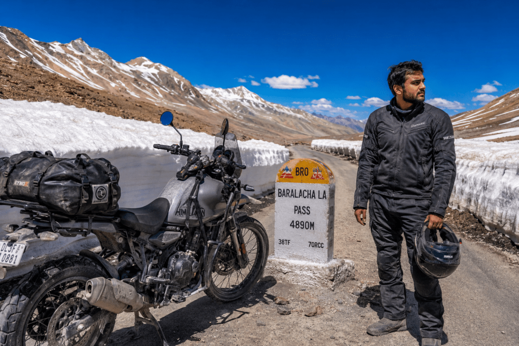
- Baralacha La (4,890m): The first serious high pass. Snow walls possible even in July.
- Bharatpur: Single tea tent in the middle of nowhere — has been there for decades
- Sarchu (4,253m): The state border campsite — tent camps on a flat river plain. Wind is constant and fierce. Sleep here if acclimatising. Skip if feeling good and push to Pang.
- Lachulung La (5,059m): The pass most people underestimate because Tanglang La is ahead
- Pang (4,600m): Small camp settlement — the More Plains begin here
Stage 3: Sarchu/Pang → Leh (200–250km, 8–10 hours)
- More Plains: 40km of flat, high-altitude plain — mesmerizing and slightly surreal. No trees. No houses. Just road and sky.
- Tanglang La (5,328m): One of the world’s highest motorable passes. The view from the top — in every direction, brown and white mountains at or below your eye level — stops every first-timer cold.
- Upshi: The descent back to the Indus Valley — the landscape changes completely
- Leh arrival: Deserved. Take two days to acclimatise before doing anything strenuous.
Nearby Places to Visit (Along the Route)
- Sissu Waterfall (near Keylong): Visible from the road in the Lahaul valley — a wide cascade into the Chandra River
- Suraj Tal Lake: Just below Baralacha La — one of India’s highest freshwater lakes, extraordinary colour
- Deepak Tal (Comet Lake): Near Baralacha La base — turquoise, remote, rarely visited
- More Plains viewpoint: Stop the vehicle, turn off the engine, stand in the silence
Food on the Manali-Leh Highway
Manali (start): Full meal at any Vashist restaurant — try the Himachali dham (traditional festive meal on a pattal leaf plate — rajma, rice, mash dal, boor ki kadi, meetha). ₹200–400.
Keylong: Last proper restaurant — Sonam Dhaba serves excellent dal-chawal and thukpa. ₹120–200.
Sarchu camp dhabas: Dal, rice, roti, maggi — cooked at 4,250m altitude on gas stoves. Limited menu, warm hospitality. ₹150–300. Don’t negotiate too hard — these people carry everything up here.
Pang: Single row of camp restaurants. Rajma-rice is always available. The first bowl after a long day of passes is one of the most satisfying meals on any road trip in India.
Tanglang La tea stall: The highest tea stall in the world (disputed but plausible). A cup of chai at 5,328m tastes like victory. ₹20–30.
2-Wheeler vs 4-Wheeler Guide
2-Wheeler:
- Ideal bike: Royal Enfield Himalayan 450, Hero XPulse 400, RE Thunderbird (can manage)
- Rental in Manali: ₹1,800–2,800/day for Himalayan 450
- Essential: Bash plate, good tyres (replace if worn), 5-litre jerry can, toolkit
- Water crossings: Multiple on Gramphu-Batal section (if taking old Rohtang route)
- The Atal Tunnel eliminates Rohtang Pass — recommended for bikes
4-Wheeler:
- Minimum: Mahindra Scorpio-N, Thar, Bolero — SUV mandatory
- Sedan: Do not attempt past Gramphu junction
- Fuel: Fill completely at Manali and Keylong — no reliable fuel between
- Drive slowly on descents — brake fade at altitude is real
Difficulty Ratings
- Beginner rider/driver: ❌ NOT recommended — this is an advanced route
- Intermediate (1–2 years highway experience): Start from Leh side via Srinagar highway (gentler)
- Advanced/Expert: The full Manali-Leh in both directions is the goal
Itinerary (4 days, Manali to Leh)
| Day | Route | Distance | Overnight |
|---|---|---|---|
| Day 1 | Manali → Jispa (via Atal Tunnel) | 115km | Jispa camp/teahouse |
| Day 2 | Jispa → Sarchu → Pang | 200km | Pang camp |
| Day 3 | Pang → Leh (via Tanglang La) | 160km | Leh hotel |
| Day 4 | Acclimatise in Leh | — | Leh |
Budget per person (4 days, own vehicle):
- Budget: ₹6,000–10,000 (camping, local food, fuel split)
- Mid-range: ₹15,000–25,000 (hotels, restaurants, fuel)
Route 2: Delhi to Leh — The Crown Jewel of Indian Road Trips
Total Distance: approximately 1,000 kilometres (Delhi to Leh via Manali) or 1,100km via Chandigarh-Manali route Ideal Duration: 7–10 days with proper stops Best Season: June–September 2-Wheeler Rating: ⭐⭐⭐⭐⭐ (Expert — the ultimate Indian motorcycle journey) 4-Wheeler Rating: ⭐⭐⭐⭐⭐ (Advanced — the complete road trip)
The road trip from Delhi to Leh-Ladakh is often considered the crown jewel of all India road trips. This route is not just a drive — it’s a test of endurance, a visual spectacle, and a deeply transformative journey.
The Delhi to Leh road trip is what people mean when they say “I want to do THE India road trip.” It is five different India’s in sequence: the plains of Haryana, the Shivalik foothills, the Kullu Valley, the Lahul cold desert, and finally the Ladakh trans-Himalayan plateau. You start in a city of 30 million people and you arrive at a valley of 30,000 people and the distance between those two worlds is not just 1,000 kilometres — it’s everything.
Route Breakdown
Delhi → Chandigarh (260km, 4 hours): NH-44 is excellent four-lane highway throughout. Chandigarh for the night — the cleanest city in India, worth a walk through the Rock Garden and Sector 17.
Chandigarh → Manali (310km, 8–9 hours): NH-21 through Bilaspur, Sundernagar, Kullu. The Kullu valley section is genuinely beautiful — the Beas River alongside for much of the route. Mandi has excellent dhaba food. Kullu town for Himachali shawl shopping. Arrive Manali by evening.
Manali → Leh: As detailed in Route 1 above (3–4 days)
Key Food Stops (Delhi to Chandigarh)
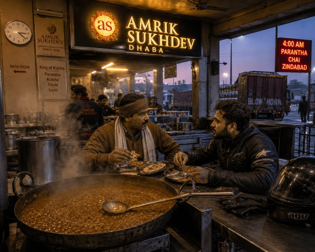
Murthal (50km from Delhi on NH-44): The legendary dhaba strip — Amrik Sukhdev, Gulshan Dhaba, Haveli are the famous names. The butter naan, dal makhani, and paneer butter masala at 3am or 7am are both equally legendary. The well-maintained NH48 highway ensures a smooth journey, with Neemrana Fort serving as a perfect mid-way stop for a heritage break.
Mandi dhaba food: Himachali siddu (steamed bread with poppy seed filling) and mash dal — specific to this region. ₹80–150 per item.
Route 3: Mumbai to Goa via NH-66 — The Coastal Highway of Dreams
Total Distance: 600 kilometres along National Highway 66, hugging the western coastline Ideal Duration: 2–3 days (rushing) | 4–5 days (the correct way) Best Season: October to March (beach weather) | Monsoon (June–September) for dramatic green and waterfalls 2-Wheeler Rating: ⭐⭐⭐⭐⭐ (Suitable from intermediate — one of India’s best bike roads) 4-Wheeler Rating: ⭐⭐⭐⭐⭐ (Ideal for all levels — smooth, scenic, manageable)
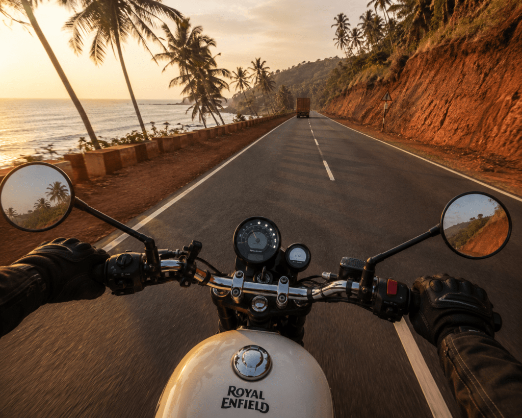
This 600-kilometer journey along National Highway 66 hugs the western coastline, offering stunning ocean views, pristine beaches, and charming coastal towns. The route passes through Maharashtra’s Konkan region, known for its lush greenery and winding roads. Historic forts like Sindhudurg and beautiful beaches such as Ganpatipule and Tarkarli dot the landscape. As you approach Goa, swaying coconut palms and Portuguese-influenced architecture welcome you. Numerous bridges crossing rivers offer postcard-worthy views.
The Mumbai-Goa highway is India’s most joyful road trip. It lacks the drama of the Himalayas and the spiritual weight of Rajasthan, but it has something both of those are sometimes too intense to deliver — the specific happiness of driving along the sea on a good road in good weather with nowhere particular to be until evening.
NH-66 from Mumbai to Goa is 600km of rotating pleasures: the Konkan coast appearing and disappearing through coconut groves, bridges over estuaries where fishing boats sit at low tide, laterite rock temples cutting the skyline, cashew orchards and mango plantations in season, and the sea — always the sea, sometimes visible for 50km continuously, sometimes gone for 20 minutes around a headland.
Two routes exist:
- NH-66 Coastal (scenic, recommended): Follows the coast closely. More stops, slower pace.
- NH-48 (Pune bypass, faster): 8–9 hours. No coast. Not the point.
Stage-by-Stage Route (NH-66)
Mumbai → Alibaug → Murud-Janjira (130km, 3 hours) The ferry from Gateway of India to Mandwa (30 minutes) bypasses Mumbai traffic completely — start the coastal road from Mandwa. Alibaug beach for a quick stop. Murud-Janjira — the sea fort visible from shore that was never captured by any enemy, accessible by boat (₹60 return).
Murud → Harihareshwar → Ganpatipule (160km, 4 hours) Harihareshwar is a temple town at a headland — the beach here with the temple on the rock is one of the finest compositions on the entire Konkan coast. Ganpatipule has a beach that’s considered one of the cleanest in Maharashtra and a temple almost on the waterfront.
Ganpatipule → Ratnagiri → Sindhudurg (200km, 4.5 hours) Ratnagiri is the Alphonso mango capital — seasonal (March–June), but the town year-round has excellent seafood. Sindhudurg Fort — Shivaji Maharaj’s island sea fort, accessible by boat, the most spectacular coastal fort in Maharashtra. Nearby Tarkarli has the clearest water on the Konkan coast — snorkelling available.
Sindhudurg → Goa (120km, 2.5 hours) The last stretch into Goa — you cross the Terekol estuary (small ferry crossing, free for 2-wheelers) or continue on the highway into Panaji via Pernem. The Konkan transforms almost exactly at the state border into Goa’s particular aesthetic — terracotta-tiled houses, palm shadows on white walls.
Nearby Places to Visit (NH-66 Stops)
- Murud-Janjira: Sea fort boat trip (₹60)
- Harihareshwar Beach: Temple + headland viewpoint
- Ganpatipule Beach: Swimming, Ganpati temple
- Tarkarli: Snorkelling and scuba diving (Malvan Marine Sanctuary)
- Sindhudurg Fort: Island fort tour (boat ₹80 return)
- Vijaydurg: Another coastal fort — less visited than Sindhudurg, more atmospheric
- Vengurla: Portuguese-era lighthouse and quiet beaches
Food on the Mumbai-Goa Coastal Route
Konkan coast seafood dhabas (all along NH-66): The roadside dhabas between Alibag and Malvan serve the freshest seafood in India. The fish arrives from the local catch that morning. Surmai (king mackerel) fry, bombil (Bombay duck) fry, rawa-coated pomfret, and the specific Malvani fish curry with red coconut base — different from Goa’s and different from Kerala’s.
Must-try dishes:
- Sol Kadhi: Pink kokum and coconut milk digestive — ₹50–80. Available at every Konkani restaurant.
- Kombdi Vade: Malvani chicken curry with fried rice flour bread — ₹200–350
- Masala Bhaat (Konkani): Spiced rice with fresh coconut and local vegetables
- Fishermen’s chai at roadside stalls: ₹15–25 — served in small glasses with condensed milk
2-Wheeler vs 4-Wheeler Perspective
2-Wheeler: NH-66 is one of India’s great bike roads — smooth, coastal, with enough curves to stay interesting without being dangerous. Intermediate riders upward will love every kilometre. A Royal Enfield Classic 350 or Bullet is the ideal bike for this route aesthetically. The Malvan and Tarkarli sections have some narrow bridges — take them slowly.
4-Wheeler: A comfortable sedan (Swift, i20, even a hatchback) handles NH-66 perfectly — this is not a difficult road. The stops are worth planning: keep the boot empty enough for fresh fish, mangoes (in season), and Malvani spices from the Malvan market.
Itinerary (4 Days, Mumbai to Goa)
| Day | Route | Distance | Overnight | Food Focus |
|---|---|---|---|---|
| Day 1 | Mumbai → Murud-Janjira | 130km | Murud | Bombil fry, Sol Kadhi |
| Day 2 | Murud → Ganpatipule | 160km | Ganpatipule | Kombdi Vade, Surmai fry |
| Day 3 | Ganpatipule → Tarkarli/Malvan | 140km | Malvan | Malvani fish curry, Tisrya (clams) |
| Day 4 | Malvan → Goa | 160km | Panjim/North Goa | Goan fish curry rice |
Budget per person (4 days, own vehicle):
- Budget: ₹4,000–7,000
- Mid-range: ₹10,000–18,000
- Luxury (boutique stays at Malvan/Goa): ₹25,000–45,000
Route 4: Jaipur to Jaisalmer — The Desert Highway
Total Distance: 575km via Jodhpur | 560km via NH-11 direct Ideal Duration: 3–4 days (with Jodhpur detour) | 2 days (direct) Best Season: October to February 2-Wheeler Rating: ⭐⭐⭐⭐ (Beginner-friendly — flat, straight, manageable) 4-Wheeler Rating: ⭐⭐⭐⭐⭐ (All levels — smooth NH throughout
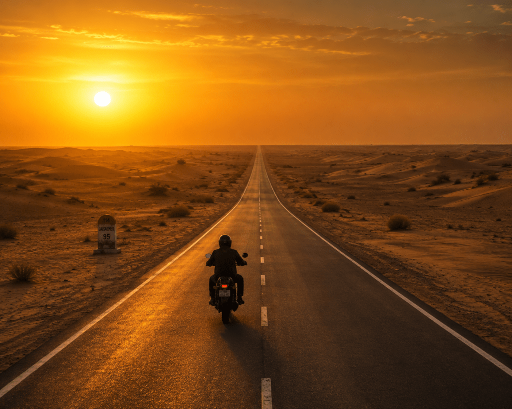
The desert route across Rajasthan is India’s most cinematic road trip. Literally — more Bollywood films have been shot on the NH-11 and NH-62 between Jaipur and Jaisalmer than on any other highway in India. The landscape starts subtle (the transition from green Jaipur’s outskirts to the scrub desert of Nagaur) and becomes increasingly dramatic until the dunes of the Thar appear and you understand why they call this the Golden Desert.
Witness Rajasthan’s colors, culture, and beauty as you ride by the various villages that line the roadways from Jaipur to Jaisalmer. Make a stop in Jodhpur to experience authentic Rajasthani traditions and cuisine. On the route, visitors can stop by the Kumbhalgarh Wildlife Sanctuary. The roads along this path are in excellent condition, ensuring a smooth ride.
Stage-by-Stage Route
Jaipur → Ajmer/Pushkar (145km, 2.5 hours): NH-48 southwest from Jaipur. Ajmer holds the Dargah Sharif — one of the most significant Sufi shrines in the world, open to all faiths. Pushkar, 14km from Ajmer, is the only Brahma temple in India with a sacred lake — one of the most photographically extraordinary small towns in Rajasthan.
Pushkar → Jodhpur (200km, 3.5 hours): NH-58 through rolling desert landscape. Jodhpur is worth 1.5 days minimum — Mehrangarh Fort (one of India’s most imposing hill forts), the Blue City lanes beneath it, Umaid Bhawan Palace, and the market district.
Jodhpur → Jaisalmer (290km, 4 hours): The roads are in excellent condition, ensuring a smooth ride. The highway runs straight through increasingly desert landscape — by the last 100km, sand dunes appear in the distance and the sky opens up enormous and cloudless.
Nearby Places to Visit
- Pushkar Camel Fair (November annually): The world’s largest camel trading fair — extraordinary spectacle
- Mehrangarh Fort, Jodhpur: The most dramatically positioned fort in India — on a sheer rock above the Blue City
- Kumbhalgarh: The fort with the world’s second-longest wall (36km) — detour of 90km from Jodhpur worth every kilometre
- Jaisalmer Fort (Living Fort): Still inhabited — shops, guesthouses, restaurants inside the walls
- Sam Sand Dunes (Jaisalmer): Sunset camel ride (₹300–500) on the classic Thar dunes
Food on the Desert Route
Dal Baati Churma: The iconic Rajasthan road trip dish — baked wheat balls with lentil dal and ghee-sweetened crushed wheat. Available at every dhaba from Jaipur to Jaisalmer. ₹180–350.
Jodhpur must-eat: Mirchi Bada (large green chilli stuffed with spiced potato, battered and fried — ₹30–50 at clock tower market). Makhaniya Lassi (thick saffron-rose lassi at Shri Mishrilal Hotel near clock tower — ₹60–80).
Jaisalmer: Ker Sangri (desert bean and berry preparation unique to the Thar — ₹150–250), mutton gatta curry (chickpea flour dumplings in spiced mutton gravy).
Pyaaz Kachori: The ubiquitous road snack — onion-stuffed fried pastry available at every Rajasthan dhaba. ₹20–40.
Itinerary (4 Days, Jaipur to Jaisalmer via Jodhpur)
| Day | Route | Distance | Overnight | Highlight |
|---|---|---|---|---|
| Day 1 | Jaipur → Pushkar | 145km | Pushkar | Brahma Temple sunset |
| Day 2 | Pushkar → Jodhpur | 200km | Jodhpur | Mehrangarh Fort |
| Day 3 | Jodhpur → Jaisalmer | 290km | Jaisalmer | Blue to Golden city drive |
| Day 4 | Jaisalmer local | — | Jaisalmer | Fort + Sam dunes |
THE COASTAL ROUTES
Route 5: Chennai to Pondicherry — East Coast Road (ECR)
Total Distance: 150 kilometres along the scenic State Highway 49, running along the Bay of Bengal coastline Ideal Duration: 1.5–2 days (if you stop properly) Best Season: November to February 2-Wheeler Rating: ⭐⭐⭐⭐⭐ (Beginner-friendly — perfect first coastal bike ride) 4-Wheeler Rating: ⭐⭐⭐⭐⭐ (All levels — smooth, scenic, accessible)
This scenic road trip starts in Chennai, the capital of Tamil Nadu, and winds down in Pondicherry, where French cafes line cobbled streets and history whispers from colourful houses. The well-maintained road offers breathtaking views of the Bay of Bengal on one side and picturesque landscapes on the other.
The East Coast Road is India’s finest short road trip — 150km of smooth, coastal highway where the Bay of Bengal appears between casuarina trees and fishing villages, and every stop has a story.
Stage-by-Stage Route + Stops
Chennai → Mahabalipuram (60km, 1.5 hours): The first major stop — Mahabalipuram (Mamallapuram) has UNESCO heritage rock temples and sculptures directly on the beach. The Shore Temple stands at the water’s edge. The Five Rathas (stone temple chariots) are carved from single boulders. Entry: ₹600 for foreigners / ₹40 for Indians.
Mahabalipuram → Auroville/Pondicherry (90km, 2 hours): Pass through Auroville, the experimental township near Pondicherry. Pondicherry offers French colonial architecture, quaint cafes, and pristine beaches. The blend of Indian and French cultures creates a unique atmosphere.
The French Quarter of Pondicherry — White Town — has yellow walls, bougainvillea, cobblestoned lanes, and the most unexpected café culture in South India. Café des Arts, Villa Shanti, and Café des Arts serve proper café au lait and croissants in an Indian coastal town.
Food on the ECR
Fresh seafood dhabas south of Chennai: Lobster, tiger prawns, crab — cooked to order from the daily catch. ₹300–800 depending on catch.
Mahabalipuram: Seafood restaurants at Tiger Cave Beach area. Butter garlic prawns ₹350–500.
Pondicherry French Quarter:
- Le Café (beach promenade): Croissants, French press coffee, pain au chocolat. ₹150–300.
- Rendezvous restaurant: Crepes and Pondicherry-style fish curry. ₹400–700.
South Indian Tiffin stops along ECR: Idli, sambar, and filter coffee at local “hotels” (what locals call small restaurants). ₹60–100 for a full breakfast.
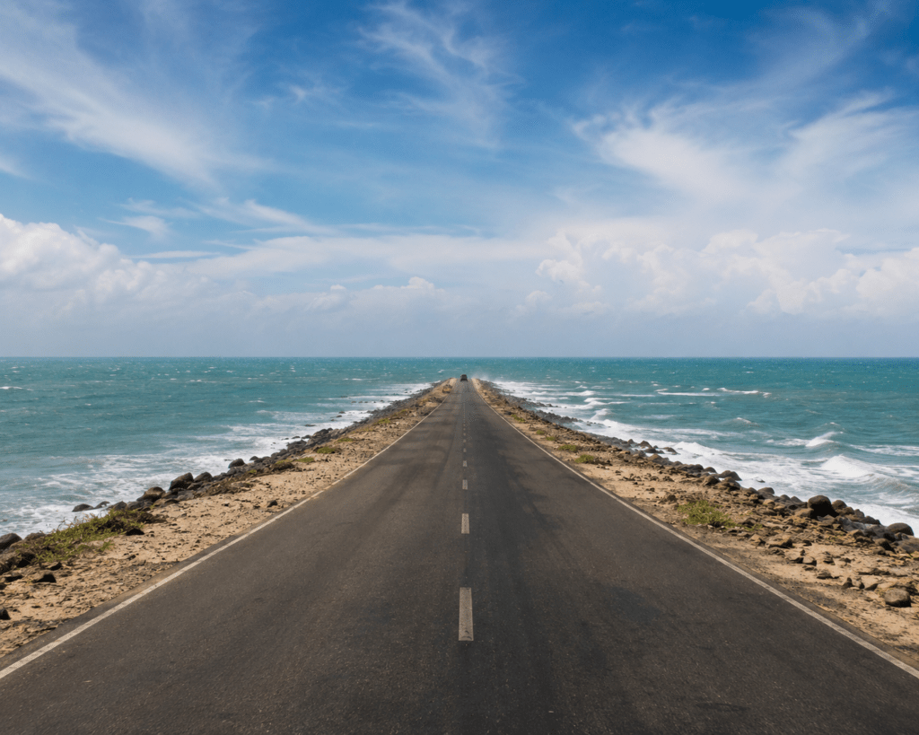
Route 6: Rameswaram to Dhanushkodi — Driving Into the Sea
Total Distance: approximately 18 kilometres Ideal Duration: Half a day from Rameswaram Best Season: October to March 2-Wheeler Rating: ⭐⭐⭐⭐⭐ (The most dramatic short bike route in India) 4-Wheeler Rating: ⭐⭐⭐⭐ (Some sandy sections near Dhanushkodi end)
The road from Rameswaram to Dhanushkodi stretches across a narrow strip of land, with water visible on both sides, creating the illusion of driving straight into the sea. The landscape is stark, windswept, and hauntingly beautiful, culminating in the remains of a town abandoned after a cyclone decades ago. There’s a quiet, almost surreal energy here, where history, mythology, and geography intersect.
Dhanushkodi was a thriving town until 1964 when a cyclone killed 1,800 people and destroyed it completely. The government declared the area unfit for habitation. What remains is a ghost town on a narrow spit of land where the Indian Ocean and the Bay of Bengal meet. The Adam’s Bridge — the chain of shoals said to be the causeway Rama built to Lanka — begins here.
This 18km drive is one of the most emotionally and visually unusual road experiences in India.
Route 7: Konkan Coast Partial Drive — Kundapur, Karnataka
Distance: approximately 15–20 kilometre stretch near Kundapur, coastal Karnataka Duration: 20–30 minutes but stop frequently Season: October to March
There are stretches of road that feel almost unreal, and this one in coastal Karnataka is firmly in that category. Here, the highway runs between two bodies of water — the Arabian Sea on one side and a calm river on the other — creating a rare, almost symmetrical landscape. The experience is less about distance and more about the sensation of being suspended between two worlds. It’s especially magical at sunset, when both water bodies catch the light and mirror the sky.
This is the road that people on the Mumbai-Goa run often miss because it requires getting off NH-66 onto a parallel coastal road near Kundapur. The reward — driving with sea on your left and a river on your right — is one of the most spatially unusual sensations available on any Indian road.
THE SOUTH INDIAN ROUTES
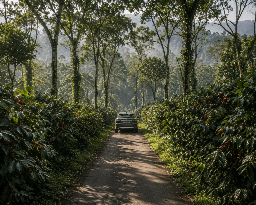
Route 8: Bangalore to Coorg — The Coffee Plantation Drive
Total Distance: approximately 250 kilometres — this journey is defined by smooth highways, lush coffee plantations, and mist-covered hills Ideal Duration: 2–3 days Best Season: September to January 2-Wheeler Rating: ⭐⭐⭐⭐ (Good roads but some ghat sections for intermediate riders) 4-Wheeler Rating: ⭐⭐⭐⭐⭐ (All levels — excellent highway throughout)
Covering around 250 kilometers, this journey is defined by smooth highways, lush coffee plantations, and mist-covered hills that slowly replace the cityscape. As you leave Bangalore, the road transitions into scenic countryside dotted with coconut trees and small towns. The real magic begins as you approach Coorg, also known as the “Scotland of India.” The air turns cooler, the roads wind through dense forests, and the aroma of coffee fills the surroundings.
Coorg (Kodagu) is Karnataka’s most dramatically beautiful district — a landscape of coffee and spice estates covering rolling hills at 900–1,700m elevation. The drive from Bangalore through Mysore to Coorg transitions through three completely different landscapes: the Deccan plain, the royal capital of Mysore, and the forest-covered Coorg.
Stage-by-Stage Route
Bangalore → Mysore (150km, 3 hours): NH-275 — excellent highway. Mysore is worth a half-day stop for the Mysore Palace (illuminated Sunday evenings — extraordinary), Devaraja Market (incense, silk, jasmine), and the Brindavan Gardens.
Mysore → Madikeri/Coorg (120km, 3 hours): The road climbs from the Deccan plateau into the Western Ghats via the ghats section. Coffee and cardamom estates line both sides from Kushalnagar onward. Madikeri (the district headquarters) has the Madikeri Fort, Raja’s Tomb, and the best Coorg filter coffee you will find anywhere.
Coorg interior drives: Abbey Falls (3km from Madikeri), Nagarhole National Park (60km from Madikeri — safaris for elephants and tigers), Brahmagiri Peak trek.
Food on the Bangalore-Coorg Route
Mysore: Mysore Pak (the original from Guru Sweets near palace — ₹50–80 for 100g), the Mysore masala dosa at any old Mysore restaurant (₹80–150).
Coorg cuisine:
- Pandi Curry (Coorg pork curry): Slow-cooked with kachampuli (Coorg vinegar) — rich, dark, sour. The defining dish of Coorg. ₹250–400.
- Kadambuttu: Steamed rice balls served with Pandi Curry — the traditional Coorg combination
- Bamboo shoot curry: Forest-foraged bamboo in coconut gravy — seasonal, extraordinary ₹200–350
- Coorg filter coffee: Stronger and better than Bangalore — served in the traditional tumbler-davara set at any estate homestay. ₹30–50.
- Baimbale Payasa (bamboo shoot payasam): The Coorg dessert — a seasonal sweet pudding using young bamboo shoots and jaggery
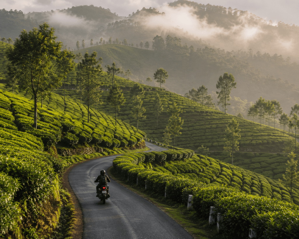
Route 9: Munnar to Alleppey — Kerala’s Green Corridor
Total Distance: 175km — beginning from the misty heights of Munnar, known for its tea garden tracts, going downhill through green vales, tropical forests, and stunning waterfalls. Near Alleppey, the terrain transitions to beautiful paddy fields, palm tree-lined highways, and tranquil backwaters. Ideal Duration: 2–3 days Best Season: September to March 2-Wheeler Rating: ⭐⭐⭐⭐ (The ghat sections are spectacular — intermediate riders) 4-Wheeler Rating: ⭐⭐⭐⭐⭐ (All levels — excellent Kerala roads)
This is the most geographically diverse road in Kerala — you begin in Munnar’s tea gardens at 1,500m and descend through the Western Ghats to Alleppey’s sea-level backwaters in 175km. The landscape changes every 20km: tea estates to rubber plantations to spice gardens to coconut palms to paddy fields to the backwater network.
Stage-by-Stage Route
Munnar (1,500m): Tea factories, Eravikulam National Park (Nilgiri Tahr), Mattupetty Dam viewpoint. The drive out of Munnar on the Marayoor road passes through sandalwood forests — rare in India.
Munnar → Thekkady (90km, 3 hours): Descending through spice country — pepper vines, cardamom, nutmeg, cinnamon visible in the plantation corridors.
Thekkady → Alleppey (100km, 3 hours): The road flattens into the Kuttanad — the “rice bowl of Kerala” where paddy fields sit below sea level, canals replace roads in places, and coconut palms replace the highland forest.
Alleppey: Houseboat boarding for the backwater circuit — the natural culmination of this drive.
Food on the Munnar-Alleppey Route
Munnar: Cardamom-spiced tea at estate tea shops (₹30–50), Kerala parotta with beef fry at local hotels (₹150–250).
Thekkady: Spice plantation lunch — fresh pepper, cardamom, nutmeg in the food. Abraham’s Spice Garden restaurant (₹300–500 for a meal using their own plantation produce).
Kuttanad/Alleppey: Karimeen pollichathu (pearl spot fish cooked in banana leaf with masala — the signature dish of Kerala’s backwaters — ₹350–500), green mango fish curry with red Kerala rice.
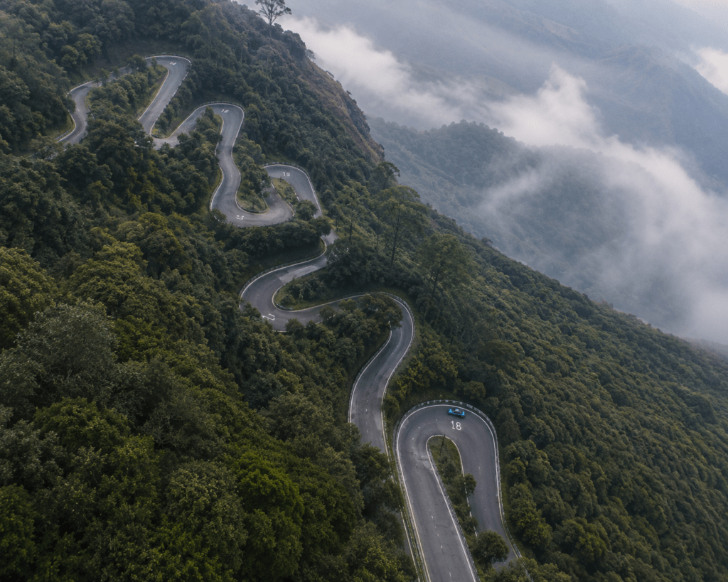
Route 10: Bangalore to Ooty — The 36 Hairpin Bends
Total Distance: 533 km for the full Bangalore-Ooty road. Famous for its 36 hairpin bends. Ideal Duration: 2 days Best Season: September to March 2-Wheeler Rating: ⭐⭐⭐⭐⭐ (Intermediate to Advanced — hairpin bends require skill) 4-Wheeler Rating: ⭐⭐⭐⭐ (Intermediate — ghat sections need driving confidence)
The Bangalore to Ooty road is famous for its 36 hairpin bends. On both sides of the road, you will find tall trees and lush green grasslands. While traveling through this road, you can also make a pit-stop at Mudumalai National Park.
The Gudalur ghat section — 36 hairpins between the Mudumalai wildlife corridor and Ooty’s Nilgiri plateau — is among the most technically demanding and visually spectacular driving experiences in South India. The hairpins are numbered (1 to 36) and locals will tell you the specific corners that require the most care.
Food on the Bangalore-Ooty Route
Mysore: (En route — see Coorg section) Gudalur (Nilgiris base): Kerala-Tamil border food — excellent meen curry (fish curry) ₹200–350 Ooty: Ooty varkey (layered sweet bread — ₹30–50/packet), Nilgiri tea (buy directly from estate shops — significantly cheaper than city prices), homemade chocolate from local shops
THE NORTHEAST ROUTES
Route 11: Guwahati to Tawang — The Most Wild Road in India
Total Distance: 520 kilometres — numerous hairpin bends on this route and the entire experience can be a little thrilling. Ideal Duration: 4–5 days Best Season: March to October (Sela Pass closed in winter) 2-Wheeler Rating: ⭐⭐⭐⭐⭐ (Expert only — remote, high altitude, poor roads in sections) 4-Wheeler Rating: ⭐⭐⭐⭐ (Advanced — SUV strongly recommended) PERMIT REQUIRED: Inner Line Permit (ILP) for all non-Arunachal Pradesh residents. Apply at eiltarunachalpradesh.gov.in or at entry checkpoints.
Guwahati to Tawang — you can simply call it a magical journey. There are numerous hairpin bends in this route and the entire experience can be a little thrilling. However, adventure lovers will love this road trip and enjoy the views thoroughly.
The Tawang road is the Northeast’s answer to the Manali-Leh Highway — but wilder, less travelled, and with a specific quality that comes from driving through the Arunachal hills where the forest is dense, the rivers are jade-green and fast, and the monasteries appear on clifftops as if they had always been there.
Tawang’s Tawang Monastery — the largest Buddhist monastery in India — sits at 3,048m above a valley that has been inaccessible to most of India for most of India’s history. The permit requirement (ILP) means the journey retains a frontier quality that the Ladakh highway has largely lost.
Stage-by-Stage Route
Guwahati → Tezpur (180km, 3 hours): NH-27 through Assam’s tea country. Nameri National Park (excellent elephant and tiger territory) is 30km from Tezpur.
Tezpur → Bomdila (175km, 6 hours): The road enters Arunachal Pradesh at Bhalukpong — ILP checkpoint. The road climbs through Pakke Tiger Reserve (excellent hornbill country) to Bomdila at 2,415m.
Bomdila → Tawang (175km, 7 hours): The most dramatic section. Sela Pass (4,176m) is the high point — a glacial lake at the pass, a WWII memorial, and views into Tibet on clear days. The descent into the Tawang valley is one of the great reveals in Indian road tripping.
Food on the Guwahati-Tawang Route
Guwahati: Masor Tenga (Assamese sour fish curry — ₹200–350), Assamese thali with pitha (steamed rice cakes) and xaadul (fermented bamboo). Try Khorikota restaurant in Guwahati.
Bomdila: Tibetan thukpa and momos — altitude comfort food. Yak milk tea available (slightly different from Ladakh butter tea — less salted, slightly sweet). ₹80–150.
Tawang: Butter tea (ja), yak butter applied to everything, Zan (roasted barley porridge), Thukpa. The local chang (millet beer) at homestays.
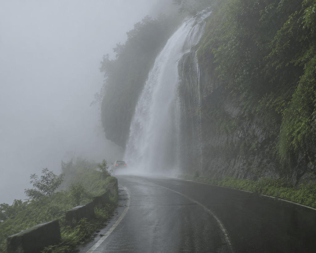
Route 12: Shillong to Cherrapunjee — The Wettest Road on Earth
Total Distance: 55 kilometres — a road that is blanketed by fog, while the slight rain drenches you Ideal Duration: Full day from Shillong Best Season: June to October (monsoon — the reason you come) 2-Wheeler Rating: ⭐⭐⭐⭐⭐ (Intermediate — fog and rain require care) 4-Wheeler Rating: ⭐⭐⭐⭐⭐ (All levels)
Do you ever want to travel through a road that is blanketed by fog, while the slight rain drenches you? Well, you can get precisely this experience in the Shillong to Cherrapunjee road. It will only take one and a half hours to reach Cherrapunjee.
Cherrapunjee (Sohra) holds the record for the highest rainfall in a single month in recorded history — 9,300mm in July 1861. The road from Shillong descends through the Khasi Hills into the cloud-trapped valley where Cherrapunjee sits above a continuous series of waterfalls that drop into the Bangladesh plains below.
The drive in monsoon is technically through a cloud — visibility sometimes drops to 20 metres, waterfalls appear suddenly on both sides of the road, the road glistens, and the landscape is the specific vivid green that only occurs when something has been rained on continuously for three months.
Nearby Places
- Nohkalikai Falls (Cherrapunjee): The tallest plunge waterfall in India (340m)
- Seven Sisters Falls: Visible from the Cherrapunjee viewpoint during monsoon
- Living Root Bridges (Nongriat village): The famous double-decker root bridge — 3km trek from Tyrna village base
- Mawsmai Cave: Limestone cave within Cherrapunjee
Food
Shillong: Jadoh (Khasi rice and pork blood rice — the most distinctive food of Meghalaya — ₹120–200), Doh Khlieh (pork salad with onion and chilli — ₹150–250 at Police Bazaar area dhabas).
Cherrapunjee local food: Tungrymbai (fermented soybean paste with pork — ₹200–350), simple rice with smoky pork at the village rest stops near the waterfall viewpoints.
THE SHORT ICONIC ROUTES
Route 13: Visakhapatnam to Araku Valley
Total Distance: 114 kilometres Ideal Duration: 1.5–2 days Best Season: October to March 2-Wheeler Rating: ⭐⭐⭐⭐⭐ (Beginner-friendly and spectacular) 4-Wheeler Rating: ⭐⭐⭐⭐⭐ (All levels — one of Andhra’s finest drives)
Both sides of the road are dotted with verdant greenery. It is a 3-hour road trip and you will enjoy it through-out.
Araku Valley is Andhra Pradesh’s hill station — a coffee-growing tribal region in the Eastern Ghats that receives surprisingly few visitors given how extraordinary the drive is. The road climbs through 36 curves from the Visakhapatnam coastal plain into the valley, passing through tunnels, waterfalls, and dense forest. The tribal (Adivasi) communities of Araku grow their own coffee — Araku Coffee has won international awards and is arguably India’s finest single-origin coffee.
Food at Araku:
- Araku Coffee at the ITDA coffee plantation outlet — ₹80–120 for a cup, ₹400–800 for a pack
- Bamboo chicken (chicken cooked inside a sealed bamboo tube over open fire) — ₹250–400
- Tribal-style millet rotis and leafy vegetable curries at the local tribal cooperative restaurant
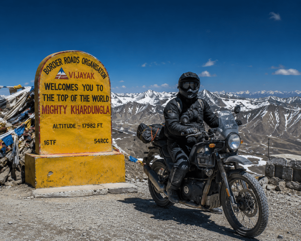
Route 14: Leh to Nubra Valley — The World’s Highest Road
Total Distance: 125 kilometres from Leh to Hunder — this incredible journey takes you through Khardung La, one of the world’s highest motorable passes. The landscape changes from dry, rugged mountains to meadows and finally to the vast sand dunes of the cold desert. Ideal Duration: 2–3 days (Leh-Nubra-back) Best Season: June–September 2-Wheeler Rating: ⭐⭐⭐⭐⭐ (Advanced — Khardung La at 5,359m requires experience) 4-Wheeler Rating: ⭐⭐⭐⭐ (Advanced — SUV for Khardung La condition)
Khardung La (5,359m) — the gateway to Nubra Valley — is one of the world’s highest motorable passes. The descent from Khardung La into the Shyok River valley and then the Nubra Valley proper is one of the most dramatic landscape transitions in Ladakh — from harsh high-altitude desert to a valley with poplar trees, sandy riverbanks, and the sand dunes of Hunder where Bactrian (double-humped) camels walk on what looks impossible for Ladakh.
Food in Nubra:
- Apricot-based preparations (Nubra grows extraordinary apricots) — fresh (June–August), jam year-round
- Tibetan thukpa and momos at Hunder guesthouses
- Chhang (local barley beer) at village homestays
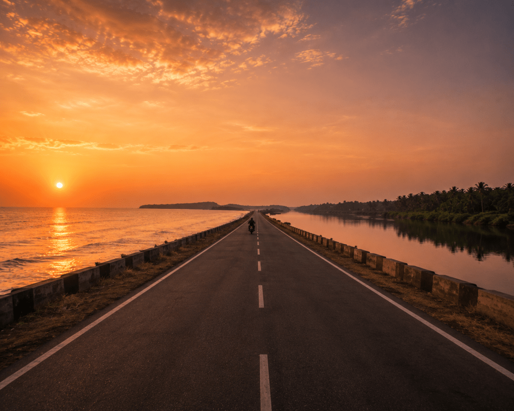
Route 15: Delhi to Rishikesh — The Ganga Valley Highway
Total Distance: 260km Ideal Duration: 1 day (fast) | 2 days (with Haridwar stop) Best Season: Year-round (best October–March and March–June) 2-Wheeler Rating: ⭐⭐⭐⭐⭐ (Beginner-friendly — one of the best starter road trips from Delhi) 4-Wheeler Rating: ⭐⭐⭐⭐⭐ (All levels)
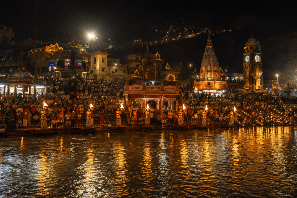
The Delhi to Rishikesh route is the most frequently driven road trip from the capital — for good reason. NH-58 is well-maintained throughout, the drive through Roorkee and Haridwar is comfortable, and the arrival in Rishikesh — where the Ganga emerges from the Himalayan foothills into the plains — is the specific moment that makes you understand why this town has been drawing seekers from across the world for centuries.
Route: Delhi → Meerut (70km) → Roorkee (100km) → Haridwar (220km) → Rishikesh (260km)
Haridwar detour: Non-negotiable. The Har Ki Pauri ghat evening aarti — thousands of diyas on the Ganga at dusk — is one of the great experiences in North India.
Food on the route:
- Murthal (40km from Delhi): See Route 2 for dhaba details
- Haridwar: Pure vegetarian city — Puri sabzi at Mohan’s Puri Shop near Har Ki Pauri (₹60–80), Aloo puri at Chotta Char Dham Bhojanalay (₹80–120)
- Rishikesh: German Bakery, Little Buddha Café for traveller food (₹300–600), Chotiwala for the classic vegetarian thali
Route 16: Gangtok to Silk Route (Sikkim Eastern Himalayas)
Total Distance: 200km — links Lhasa, Tibet, to India via the Jelep La Pass in Sikkim. A ride along the motorable roads of this route affords incredible views of Mt. Kanchenjunga as well as picturesque landscapes of hills and snow. Ideal Duration: 3–4 days Best Season: May–November 2-Wheeler Rating: ⭐⭐⭐⭐ (Advanced — high altitude, remote sections) 4-Wheeler Rating: ⭐⭐⭐⭐ (Advanced — SUV recommended) PERMIT: Required for Sikkim permit + Nathu La area special permit
You may start your tour at Gangtok, Sikkim, and travel up to the Nathang Valley. While walking this path, you may see the beautiful Menmecho Lake, the Mandakini Waterfall, and the entire twisting road from Thambi View Point.
The Silk Route circuit in Sikkim is the Northeast’s finest road trip — less famous than Ladakh and Spiti but equally extraordinary. The landscape is different: lush, green, waterfalled, with Kanchenjunga (8,586m, third highest peak in the world) visible on clear days.
SLOW TRAVEL GUIDE — HOW TO ACTUALLY ENJOY THESE ROUTES
The Philosophy of Indian Road Tripping
Indian road trips have a specific enemy: ambition. The temptation to cover maximum kilometres, see maximum sights, and post maximum photographs is the thing that most consistently ruins road trips in India.
The roads that appear in this guide are not highways between destinations. They are themselves destinations. The Konkan route isn’t the way to Goa — it is the reason to drive rather than fly. The Munnar-Alleppey drive isn’t a connecting road between two tourist spots — it’s a school in why Kerala exists.
The slow travel rules for Indian roads:
Stop at every chai stall you feel drawn to. The ₹20 chai will often be better than the ₹200 café coffee. The conversation with the chai wala often tells you more about the region than three hours at a museum. This is not romance — it’s logistics intelligence. Chai wallas know the road, the weather, and the best dhaba 15km ahead better than any GPS.
Eat where the trucks are parked. Truck drivers are professional road trip planners. They drive these routes daily. The dhaba with twelve trucks outside is always better than the dhaba with aggressive signage and a parking lot for tourists.
Leave at dawn. Every road on this list is significantly better at 6am than at 10am. The light, the traffic, the temperature, the wildlife (on forest routes) — everything is improved by being early.
Plan one stop you discovered yourself. Every route has things the guides miss. The temple down a dirt road that wasn’t on any map. The viewpoint that appears suddenly. The village where someone waves you in for tea because they want to know where you came from. Leave room for these.
What to Carry — Complete Road Trip Gear Guide
Essential Documents (Every Road Trip)
- Driving licence (original — not photocopy)
- Vehicle registration (RC) — original
- Insurance certificate (valid and current)
- PUC certificate (Pollution Under Control)
- Aadhaar/ID for all passengers
- Specific permits (Arunachal ILP, Ladakh e-permit, Sikkim permit, Restricted Area Permits)
Vehicle Essentials
For all vehicles:
- Spare tyre (checked and inflated)
- Car jack and wheel spanner
- Jumper cables
- Tow rope
- Basic toolkit (spanners, screwdrivers, pliers)
- Reflective triangle and vest
- Fire extinguisher (small, mounted in boot)
For Himalayan routes (additional):
- Extra fuel (5-10 litre jerry can for bikes, 10-20 litre for cars)
- Engine oil (1-2 litres extra)
- Brake fluid
- Clutch wire and throttle cable (bikes)
- Tyre repair kit (tubeless slime + hand pump)
Personal Essentials
General:
- Power bank (20,000mAh minimum — charging points unpredictable on long routes)
- Offline Google Maps downloaded for entire route (no data on Himalayan/remote roads)
- ORS sachets (dehydration on long drives is real)
- First aid kit
- Sunscreen SPF 50+ (especially for bikers)
Himalayan routes additional:
- Warm layers (temperature swings of 20°C between valley and pass)
- Gloves, balaclava (bikers — mandatory above 4,000m)
- Altitude medication (Diamox — consult doctor before)
- Portable oxygen can (emergency use)
Coastal routes:
- Insect repellent (DEET-based for Konkan/Goa)
- Light rain jacket for monsoon driving
- Waterproof bag for electronics
Camera and Content Creation Gear
For content creators driving India’s great roads:
- DJI Osmo Action 6: Helmet or dashboard mount, 4K/60fps, waterproof
- Insta360 X4: 360° on bike mount — captures road ahead, rider, and sky simultaneously
- DashCam: Vantrue N4 Pro or equivalent — for both safety record and content
- Suction mount for car windscreen: Stabilised phone/camera mount
Difficulty Ratings by Driver/Rider Experience
For Complete Beginners (First Road Trip)
Best routes: Delhi to Rishikesh, Chennai to Pondicherry (ECR), Jaipur to Ajmer, Mumbai to Pune Expressway
Why these: Good road conditions, moderate distances (150–260km), regular petrol stations, no altitude, good phone connectivity throughout
Vehicle recommendation: Any sedan or hatchback for car. For bikes: Honda CB350, Royal Enfield Meteor 350 (low seat, comfortable, manageable power)
For Intermediate (2–5 road trips done)
Best routes: Mumbai to Goa (NH-66), Bangalore to Coorg, Visakhapatnam to Araku, Gangtok Silk Route, Guwahati to Tezpur/Bomdila section
Vehicle recommendation: Comfortable sedan or compact SUV. For bikes: Royal Enfield Classic 350/Bullet 350, Honda CB500X
For Advanced (Regular road tripper, mountain experience)
Best routes: Manali to Leh, Munnar to Alleppey via ghats, Guwahati to Tawang, Leh to Nubra via Khardung La
Vehicle recommendation: SUV minimum (Thar/Scorpio-N). Bikes: Royal Enfield Himalayan 450, Hero XPulse 400, KTM 390 Adventure
For Expert (Experienced expedition riders/drivers)
Best routes: Delhi to Leh (full 1,000km), Alang-Madan-Kulang region roads, Zanskar Valley road (Leh to Padum — one of India’s hardest roads), Spiti circuit
Seasonal Calendar — When to Do Each Route
| Season | Best Routes |
|---|---|
| Jan–Feb | Rajasthan (Jaipur-Jaisalmer), Pondicherry ECR, Coorg, Araku Valley, Kerala coast |
| March–April | All routes before heat peak — ideal for Coorg, Kerala, ECR, Rajasthan, Bangalore-Ooty |
| May–June | Himalayan routes opening — Manali-Leh (from June 15), Guwahati-Tawang, Delhi-Rishikesh |
| July–August | Himalayan routes (best time — passes clear), Shillong-Cherrapunjee, Northeast routes |
| September | All Himalayan routes (best overall), Maharashtra coastal, Coorg, ECR |
| October–November | Peak season — all routes viable. Rajasthan, Kerala, Goa coastal, Ooty, Araku all excellent |
| December | Rajasthan, ECR, Coorg, Kerala, Araku — avoid Himalayan passes (closing) |
FAQ Section
Q: What is the best road trip in India for a first-timer?
A: The Chennai to Pondicherry East Coast Road (150km) is the perfect first road trip — smooth, scenic, manageable distance, excellent food stops, and the French Quarter of Pondicherry as the reward. For those in North India, Delhi to Rishikesh (260km) on NH-58 is equally accessible and delivers the Ganga valley and Haridwar aarti as highlights.
Q: Which Indian road trip is best for bikes?
A: The Manali-Leh Highway (475km) is the crown jewel of Indian motorcycle journeys. For coastal riding, NH-66 from Mumbai to Goa is the finest. For short spectacular rides, the Ooty hairpin bends (36 curves) and the Shillong-Cherrapunjee fog road are exceptional. The Delhi-Leh full 1,000km is the ultimate for experienced riders.
Q: What is the best season for Indian road trips?
A: October to February is the best overall window — comfortable temperatures, clear skies, and most routes are fully operational. For Himalayan routes specifically, June to September is the window when passes are snow-clear. The Rajasthan desert routes are best October to February. Coastal routes (ECR, Mumbai-Goa) are excellent October to March.
Q: Is the Manali-Leh Highway safe for beginners?
A: No — the Manali-Leh Highway involves high-altitude passes, limited fuel availability, unpaved sections, water crossings (on older route), and extreme weather variability. It requires at minimum 2 years of highway driving/riding experience and ideally prior mountain road experience. Beginners should start with flatter routes and build up experience before attempting Himalayan roads.
Q: What documents do I need for a road trip across India?
A: Driving licence (original), vehicle RC, valid insurance, PUC certificate, and Aadhaar/ID for all passengers. For restricted areas: Arunachal Pradesh ILP (eiltarunachalpradesh.gov.in), Sikkim permit, Ladakh e-permits for border areas. No additional documents needed for most routes within mainland India.
Q: What is the most scenic short road trip in India?
A: The Rameswaram to Dhanushkodi drive (18km) — driving on a narrow strip of land with the ocean on both sides — is India’s most dramatic short drive. The Kundapur coastal section in Karnataka (15-20km with sea on both sides) is equally extraordinary. For mountain scenery, the Leh to Khardung La summit (38km) is unmatched in visual drama per kilometre.
Conclusion — The Road Is the Thing
India’s great roads are not connectors. They are not the thing you do to get somewhere else. They are the thing.
The tea at Sarchu at 4,250m. The pomfret fry at a Konkan dhaba where the fish came out of the sea six hours ago. The moment the Nubra Valley appears below Khardung La. The Pondicherry café at 8am where the filter coffee arrives in a steel tumbler and the sea is visible from the terrace.
These are available on every route in this guide. Not all of them, not in the same way — but each route delivers something that cannot be pre-planned and cannot be replicated on any flight or train. The journey is genuinely the destination. The kilometres between Point A and Point B are where the actual travel happens.
Pick a route. Match it to your season. Match it to your vehicle and experience. Read the food stops carefully — they’re not optional extras, they’re the chapters of the road.
Start before dawn. Drive slowly enough to stop when something surprising appears. Eat at the truck stop. Order the thing you don’t recognise on the menu.
Come back different.
The roads are all there. They have been waiting.